| Revision as of 17:05, 29 December 2012 editVs64vs (talk | contribs)108 edits Expanding article← Previous edit | Revision as of 17:08, 6 January 2013 edit undoYmblanter (talk | contribs)Autopatrolled, Administrators269,039 editsm one is a platform, another one is a stationNext edit → | ||
| Line 73: | Line 73: | ||
| '''Otradnoye''' ({{lang-ru|Отра́дное}}) is a ] in ] of ], ], located {{convert|40|km|sp=us}} east of ] on the left bank of the ], at its ] with the ]. Population: {{ru-census|p2010=23,866|p2002=21,570|p1989=22,386}} | '''Otradnoye''' ({{lang-ru|Отра́дное}}) is a ] in ] of ], ], located {{convert|40|km|sp=us}} east of ] on the left bank of the ], at its ] with the ]. Population: {{ru-census|p2010=23,866|p2002=21,570|p1989=22,386}} | ||
| A railway leading from St. Petersburg (]) to ] passes through the town; there are two passenger platforms within town limits: ] and ]. | A railway leading from St. Petersburg (]) to ] passes through the town; there are two passenger platforms within town limits: ] and ]. | ||
| ==History== | ==History== | ||
Revision as of 17:08, 6 January 2013
For other places with the same name, see Otradny. Town in Leningrad Oblast, Russia| Otradnoye Отрадное | |
|---|---|
| Town | |
 Flag Flag Coat of arms Coat of arms | |
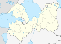
| Location of Otradnoye | |
  | |
| Coordinates: 59°46′27″N 30°47′40″E / 59.77417°N 30.79444°E / 59.77417; 30.79444 | |
| Country | Russia |
| Federal subject | Leningrad Oblast |
| Administrative district | Kirovsky District |
| Founded | 1708 |
| Elevation | 17 m (56 ft) |
| Population | |
| • Total | 23,866 |
| Municipal status | |
| • Municipal district | Kirovsky Municipal District |
| • Urban settlement | Otradnenskoye Urban Settlement |
| Time zone | UTC+3 (MSK |
| Postal code(s) | 188330, 188331 |
| OKTMO ID | 41625104001 |
| Website | www |
Otradnoye (Template:Lang-ru) is a town in Kirovsky District of Leningrad Oblast, Russia, located 40 kilometers (25 mi) east of St. Petersburg on the left bank of the Neva River, at its confluence with the Tosna River. Population: 23,866 (2010 Census); 21,570 (2002 Census); 22,386 (1989 Soviet census).
A railway leading from St. Petersburg (Moskovsky Terminal) to Volkhov passes through the town; there are two passenger platforms within town limits: Ivanovskaya and Pella.
History
A village of Ivanovskaya (Ива́новская) at the confluence of the Neva and Tosna Rivers was first mentioned in chronicles in 1708. In 1784, the land was acquired by empress Catherine the Great, and a residence known as Pella estate was established. The estate was mostly destroyed on the orders of Paul I.
The modern town was established in 1970 by merging of the urban-type settlements of Otradnoye and Ivanovskoye.
Notable people
- Evgeny Mishin - IFBB professional bodybuilder
- Zara - Russian pop singer and actress
References
- ^ Russian Federal State Statistics Service (2011). Всероссийская перепись населения 2010 года. Том 1 [2010 All-Russian Population Census, vol. 1]. Всероссийская перепись населения 2010 года (in Russian). Federal State Statistics Service.
- "Об исчислении времени". Официальный интернет-портал правовой информации (in Russian). June 3, 2011. Retrieved January 19, 2019.
- Почта России. Информационно-вычислительный центр ОАСУ РПО. (Russian Post). Поиск объектов почтовой связи (Postal Objects Search) (in Russian)
- Federal State Statistics Service (May 21, 2004). Численность населения России, субъектов Российской Федерации в составе федеральных округов, районов, городских поселений, сельских населённых пунктов – районных центров и сельских населённых пунктов с населением 3 тысячи и более человек [Population of Russia, Its Federal Districts, Federal Subjects, Districts, Urban Localities, Rural Localities—Administrative Centers, and Rural Localities with Population of Over 3,000] (XLS). Всероссийская перепись населения 2002 года (in Russian).
- Всесоюзная перепись населения 1989 г. Численность наличного населения союзных и автономных республик, автономных областей и округов, краёв, областей, районов, городских поселений и сёл-райцентров [All Union Population Census of 1989: Present Population of Union and Autonomous Republics, Autonomous Oblasts and Okrugs, Krais, Oblasts, Districts, Urban Settlements, and Villages Serving as District Administrative Centers]. Всесоюзная перепись населения 1989 года (in Russian). Институт демографии Национального исследовательского университета: Высшая школа экономики . 1989 – via Demoscope Weekly.
- http://www.getbig.com/ranking/prorankm.htm
Category: