| Revision as of 14:37, 24 March 2015 editStaticshakedown (talk | contribs)Autopatrolled, Event coordinators, Extended confirmed users, New page reviewers22,656 editsm →Gallery: c/e← Previous edit | Revision as of 14:40, 24 March 2015 edit undoStaticshakedown (talk | contribs)Autopatrolled, Event coordinators, Extended confirmed users, New page reviewers22,656 edits →Places of interest: expNext edit → | ||
| Line 101: | Line 101: | ||
| * '''Clara Rojas Museum''' has 19th century furniture and relics from the colonization period of Antioquia.<ref name="Dier2014" /> | * '''Clara Rojas Museum''' has 19th century furniture and relics from the colonization period of Antioquia.<ref name="Dier2014" /> | ||
| * '''] Nature Reserve''' | * '''] Nature Reserve''' | ||
| * '''Moto-Ratón Tour''' | * '''Moto-Ratón Tour''' - These so-called "motorcycle mouses" take visitors on a tour throughout the town. | ||
| * Rivers for catching trout. | * Rivers for catching trout. | ||
| {{wide image|Conjunto de la Plaza Principal del Municipio el Jardín. Colombia.JPG|900px}} | {{wide image|Conjunto de la Plaza Principal del Municipio el Jardín. Colombia.JPG|900px}} | ||
Revision as of 14:40, 24 March 2015
Municipality and town in Antioquia Department, Colombia| Jardín | |
|---|---|
| Municipality and town | |
 | |
 Flag Flag Seal Seal | |
 Location of the municipality and town of Jardín in the Antioquia Department of Colombia Location of the municipality and town of Jardín in the Antioquia Department of Colombia | |
| Country | |
| Department | Antioquia Department |
| Population | |
| • Total | 14,177 |
| Time zone | UTC-5 (Colombia Standard Time) |
| Website | www |
Jardín is a town and municipality in the southwest region of Antioquia, Colombia. It is bounded by the Andes, Jericó, and Támesis municipalities to the north and the Caldas department to the south. The municipality is located between the San Juan river, which is called Docató (meaning "River stones") by the natives, and a branch of the Western Cordillera. Jardín is identified by its preserved colonial architecture, lush vegetation, and abundant rivers and streams.
Among others, rivers that flow through Jardin include the San Juan, Claro, and Dojurgo. Trout that is caught in the local rivers is a popular dish in the area.
The national anthem of the town is "Hymn to Jardín".
Toponymy
Regarding the name "Garden" (Template:Lang-es) that belongs to this town, legend says that when the founders came to the so-called "Alto de las Flores" ("Top of the flowers"), from the sietecueros village, they saw the valley that is today Jardín. At the time, it was entirely a jungle, full of white snakewood and crossed by two riachuelos. On seeing the beauty of the area, the settlers began to call it a garden.
History
The earliest evidence of human settlement in the area comes from graves that probably belonged to Katíos, indigenous people, specifically of the Chamíes ethnicity. These people were also known as "Docatoes", after the nearby Docató river.
Colonization of Antioquia was at its peak in the 1860s. During this time, a settler named Indalecio Peláez claimed huge tracts of land between two riachuelos known as Volcanes and El Salado in 1863. According "Monographs of Antioquia" published in 1941 by the Brewery Union of Medellín, other settlers accompanying Pelaez included, among others, Raimundo and Jesus Maria Rojas, Juan, Antonio, José and Ignacio Ríos, Santiago, Lino, Peter and Ceferino Colorado, Hipólito and Baltasar Arenas, Nicolas Rozo, Bonifacio Amelines and Raimundo Gil.
In 1864, Dr. José María Gómez Angel, a well-known priest, and two other priests came to Jardín after fleeing from General Mosquera, who at the time was in Medellín. These priests came up with the idea to create a more independent village in the area, and they discussed this idea with the aforementioned farmers and early settlers.
In 1871 Jardín was declared a parish. In 1882 it was declared a town by Luciano Restrepo, who at the time was the president of the then Antioquia State.
Architecture
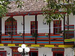
Unlike some other municipalities of Antioquia, Jardín has remained largely unchanged for the last 140 years. The colonial architecture predominant throughout the area is characterized by whitewashed buildings with brightly painted doors, balconies, and chairs.
Demographics

According to figures presented by the DANE 2005 census, the ethnographic makeup of the township is as follows:
- Mestizo and White: 89.3%
- Indigenous: 10%
- Afro-Colombian: 0.7%
Economy
- Agriculture: coffee, plantain, sugarcane, and beans
- Tourism
- Trout fishing
- Artisan crafts, traditionally made by nuns
Tourism is in this city a basic source of income. The town is unique in having over 40 hotels, when larger municipalities of Antioquia have a maximum of ten.
Places of interest
- Principle Park, declared a National Monument of Colombia in 1985. This area is frequently visited for its nearby shops and inns. The floor is paved with rocks from the Tapartó river. The site features color wooden chairs and several gardens.
- Basilica of the Immaculate Conception, declared a National Monument of Colombia in 1980. This basilica was also built from hand-cut stones from the Tapartó river nearby.
- Colorful balconies of the houses and buildings in the municipality, many of which feature flowers.
- Clara Rojas Museum has 19th century furniture and relics from the colonization period of Antioquia.
- Yellow-eared Parrot Nature Reserve
- Moto-Ratón Tour - These so-called "motorcycle mouses" take visitors on a tour throughout the town.
- Rivers for catching trout.

Gallery
-
 La Herrera ravine
-
 Principal Park
-
Basílica Menor de la Inmaculada Concepción
References
- ^ Andrew Dier (10 June 2014). Moon Colombia. Avalon Travel Publishing. p. 526. ISBN 978-1-61238-628-7.
External links
 Jardín travel guide from Wikivoyage
| Capital: Medellín | |||||||||||||||||||
| Regions and municipalities |
| ||||||||||||||||||
| Related topics | |||||||||||||||||||
5°35.99′N 75°49.19′W / 5.59983°N 75.81983°W / 5.59983; -75.81983
Categories: