| Revision as of 16:37, 1 November 2016 editMarkussep (talk | contribs)Autopatrolled, Extended confirmed users, Page movers, Pending changes reviewers, Template editors557,641 edits update← Previous edit |
Revision as of 16:00, 9 December 2016 edit undoMarkussep (talk | contribs)Autopatrolled, Extended confirmed users, Page movers, Pending changes reviewers, Template editors557,641 edits areaNext edit → |
| Line 4: |
Line 4: |
|
|name = Andros |
|
|name = Andros |
|
|name_local = Άνδρος |
|
|name_local = Άνδρος |
|
|image_map = Dimos Androu.png |
|
|image_map = DE Androu.svg |
|
|map_caption = Location within the Cyclades |
|
|map_caption = Location within Andros |
|
|periph = ] |
|
|periph = ] |
|
|periphunit = ] |
|
|periphunit = ] |
| Line 12: |
Line 12: |
|
|pop_community = 1665 |
|
|pop_community = 1665 |
|
|population_as_of = 2011 |
|
|population_as_of = 2011 |
|
|
|area_municunit = 102.8 |
|
|area = |
|
|
|elevation = |
|
|elevation = |
|
|lat_deg = 37 |
|
|lat_deg = 37 |
| Line 21: |
Line 21: |
|
|area_code = |
|
|area_code = |
|
|licence = EM |
|
|licence = EM |
|
|mayor = |
|
|
|website = |
|
|website = |
|
|image_skyline = Andros town.JPG |
|
|image_skyline = Andros town.JPG |
|
|caption_skyline = Andros town |
|
|caption_skyline = Andros town |
|
|party = |
|
|
|since = |
|
|
}} |
|
}} |
|
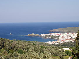
'''Andros''' ({{lang-el|Άνδρος}}), also called '''Chora''' (Χώρα, "main town"), is a town and a former ] on the island of ], in the ], ]. Since the 2011 local government reform it is part of the municipality Andros, of which it is a municipal unit, and shares the island of Andros with the municipal units of ] and ]. |
|
<ref name=Kallikratis> Greece Ministry of Interior {{el icon}}</ref> Its population was 3,901 inhabitants at the 2011 census. |
|
<ref name=Kallikratis> Greece Ministry of Interior {{el icon}}</ref> The municipal unit has an area of 102.756 km<sup>2</sup>.<ref name=stat01>{{cite web|url=http://dlib.statistics.gr/Book/GRESYE_02_0101_00098%20.pdf|publisher=National Statistical Service of Greece|title=Population & housing census 2001 (incl. area and average elevation)|language=el}}</ref> Its population was 3,901 inhabitants at the 2011 census. |
|
|
|
|
|
It has a mix of post-World War I neoclassical mansions with vernacular ] houses. The town squares are paved with marble. At the end of the headland are two islands. The first, linked to the mainland by a brick bridge, with a ruined Venetian castle and the second with a lighthouse. There are four museums: the extensive Archaeological Museum, Museum of Modern Art, a Nautical Museum and a Folklore Museum. |
 Andros town