| Revision as of 01:45, 10 October 2017 editInternetArchiveBot (talk | contribs)Bots, Pending changes reviewers5,384,353 edits Rescuing 1 sources and tagging 0 as dead. #IABot (v1.5.5)← Previous edit | Revision as of 11:30, 9 December 2018 edit undoUnderlying lk (talk | contribs)Autopatrolled, Extended confirmed users, Pending changes reviewers, Template editors53,685 editsNo edit summaryNext edit → | ||
| Line 1: | Line 1: | ||
| {{For|the village in Azerbaijan formerly called Gadzhiyevo|Qarasu, Hajigabul}} | {{For|the village in Azerbaijan formerly called Gadzhiyevo|Qarasu, Hajigabul}} | ||
| {{Infobox Russian inhabited locality | |||
| | en_name = Gadzhiyevo | |||
| {{Infobox Russian town | |||
| | ru_name = Гаджиево | |||
| |en_name=Gadzhiyevo | |||
| | loc_name1 = | |||
| |ru_name=Гаджиево | |||
| | loc_lang1 = | |||
| |image_skyline=Озеро в Гаджиеве.jpg | |||
| | loc_name2 = | |||
| |image_caption=Lake in Gadzhiyevo | |||
| | loc_lang2 = | |||
| |coordinates = {{coord|69|15|N|33|25|E|display=inline,title}} | |||
| | loc_name3 = | |||
| |map_label_position=right | |||
| | loc_lang3 = | |||
| |image_coa=Coat of Arms of Gadzhievo.png | |||
| | loc_name4 = | |||
| |coa_caption= | |||
| | loc_lang4 = | |||
| |image_flag= | |||
| | other_name = | |||
| |flag_caption= | |||
| | other_lang = | |||
| |anthem= | |||
| | image_skyline = Озеро в Гаджиеве.jpg | |||
| |anthem_ref= | |||
| | image_caption = Lake in Gadzhiyevo | |||
| |holiday= | |||
| | image_map = | |||
| |holiday_ref= | |||
| | map_caption = | |||
| |federal_subject=] | |||
| | coordinates = {{coord|69|15|N|33|25|E|display=inline,title}} | |||
| |federal_subject_ref=<ref name="MurmanskO_admlist" /> | |||
| | image_flag = | |||
| |adm_data_as_of=December 2013 | |||
| | image_coa = Coat of Arms of Gadzhievo.png | |||
| |adm_city_jur=] of ] | |||
| | anthem = | |||
| |adm_city_jur_ref=<ref name="MurmanskO_admlist" /> | |||
| | anthem_ref = | |||
| |inhabloc_cat=Town | |||
| | holiday = | |||
| |inhabloc_cat_ref=<ref name="MurmanskO_admlist" /> | |||
| | holiday_ref = | |||
| |inhabloc_type= | |||
| <!-- administrative status --> | |||
| |inhabloc_type_ref= | |||
| | federal_subject = ] | |||
| |mun_data_as_of=June 2013 | |||
| | federal_subject_ref = <ref name="MurmanskO_admlist" /> | |||
| |urban_okrug_jur=Alexandrovsk Urban Okrug | |||
| | adm_district_jur = | |||
| |urban_okrug_jur_ref=<ref name="Ref813" /> | |||
| | adm_district_jur_ref = | |||
| |leader_title= | |||
| | adm_inhabloc_jur = ] of ] | |||
| |leader_title_ref= | |||
| | adm_inhabloc_jur_ref = <ref name="MurmanskO_admlist" /> | |||
| |leader_name= | |||
| | adm_citydistrict_jur = | |||
| |leader_name_ref= | |||
| | adm_citydistrict_type = | |||
| |representative_body= | |||
| | adm_citydistrict_jur_ref = | |||
| |representative_body_ref= | |||
| | adm_selsoviet_jur = | |||
| |area_of_what= | |||
| | adm_selsoviet_type = | |||
| |area_as_of= | |||
| | adm_selsoviet_jur_ref = | |||
| |area_km2= | |||
| | capital_of = | |||
| |area_km2_ref= | |||
| | capital_of_ref = | |||
| |pop_2010census=11068 | |||
| | adm_ctr_of1 = | |||
| |pop_2010census_ref=<ref name="2010Census" /> | |||
| | adm_ctr_of1_ref = | |||
| |pop_density= | |||
| | adm_ctr_of2 = | |||
| |pop_density_as_of= | |||
| | adm_ctr_of2_ref = | |||
| |pop_density_ref= | |||
| | adm_ctr_of3 = | |||
| |pop_latest= | |||
| | adm_ctr_of3_ref = | |||
| |pop_latest_date= | |||
| | inhabloc_cat = Town | |||
| |pop_latest_ref= | |||
| | inhabloc_cat_ref = <ref name="MurmanskO_admlist" /> | |||
| |established_date=1957 | |||
| | inhabloc_type = | |||
| |established_title=First mentioned | |||
| | inhabloc_type_ref = | |||
| |established_date_ref= | |||
| <!-- municipal status --> | |||
| |current_cat_date=1981 | |||
| | mun_district_jur = | |||
| |current_cat_date_ref= | |||
| | mun_district_jur_ref = | |||
| |prev_name1=Yagelnaya Guba | |||
| | urban_okrug_jur = Alexandrovsk Urban Okrug | |||
| |prev_name1_date=1967 | |||
| | urban_okrug_jur_ref = <ref name="Ref813" /> | |||
| |prev_name1_ref= | |||
| | urban_settlement_jur = | |||
| |prev_name2=Gadzhiyevo | |||
| | urban_settlement_jur_ref = | |||
| |prev_name2_date=1981 | |||
| | rural_settlement_jur = | |||
| |prev_name2_ref= | |||
| | rural_settlement_jur_ref = | |||
| |prev_name3=Murmansk-130 | |||
| | inter_settlement_territory = | |||
| |prev_name3_date=1994 | |||
| | inter_settlement_territory_ref = | |||
| |prev_name3_ref= | |||
| | mun_admctr_of1 = | |||
| |prev_name4=Skalisty | |||
| | mun_admctr_of1_ref = | |||
| |prev_name4_date=1999 | |||
| | mun_admctr_of2 = | |||
| |prev_name4_ref= | |||
| | mun_admctr_of2_ref = | |||
| |postal_codes=184670, 184671 | |||
| | leader_title = | |||
| |dialing_codes=81539 | |||
| | leader_title_ref = | |||
| |dialing_codes_ref= | |||
| | leader_name = | |||
| |website= | |||
| | leader_name_ref = | |||
| |website_ref= | |||
| | representative_body = | |||
| |date=January 2012 | |||
| | representative_body_ref = | |||
| }} | |||
| <!-- statistics --> | |||
| | elevation_m = | |||
| | area_km2 = | |||
| | area_km2_ref = | |||
| | pop_2010census = 11068 | |||
| | pop_2010census_rank = | |||
| | pop_2010census_ref = <ref name="2010Census" /> | |||
| | pop_latest = | |||
| | pop_latest_date = | |||
| | pop_latest_ref = | |||
| | population_demonym = | |||
| | time_zone_ref = | |||
| <!-- history --> | |||
| | established_date = 1957 | |||
| | established_title = First mentioned | |||
| | established_date_ref = | |||
| | current_cat_date = 1981 | |||
| | current_cat_date_ref = | |||
| | abolished_date = | |||
| | abolished_date_ref = | |||
| <!-- misc --> | |||
| | postal_codes = 184670, 184671 | |||
| | postal_codes_ref = | |||
| | dialing_codes = 81539 | |||
| | dialing_codes_ref = | |||
| | website = | |||
| }}It was previously known as ''Yagelnaya Guba'' (until 1967), ''Gadzhiyevo'' (until 1981), ''Murmansk-130'' (until 1994), ''Skalisty'' (until 1999) | |||
| '''Gadzhiyevo''' ({{lang-ru|Гаджи́ево}}) is a ] under the administrative jurisdiction of the ] of ] in ], ]. Population: {{ru-census2010|11,068|;}} {{ru-census2002|12,180|.}} | '''Gadzhiyevo''' ({{lang-ru|Гаджи́ево}}) is a ] under the administrative jurisdiction of the ] of ] in ], ]. Population: {{ru-census2010|11,068|;}} {{ru-census2002|12,180|.}} | ||
Revision as of 11:30, 9 December 2018
For the village in Azerbaijan formerly called Gadzhiyevo, see Qarasu, Hajigabul. Town in Murmansk Oblast, Russia| Gadzhiyevo Гаджиево | |
|---|---|
| Town | |
 Lake in Gadzhiyevo Lake in Gadzhiyevo | |
 Coat of arms Coat of arms | |
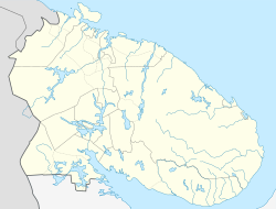
| Location of Gadzhiyevo | |
  | |
| Coordinates: 69°15′N 33°25′E / 69.250°N 33.417°E / 69.250; 33.417 | |
| Country | Russia |
| Federal subject | Murmansk Oblast |
| First mentioned | 1957 |
| Town status since | 1981 |
| Elevation | 30 m (100 ft) |
| Population | |
| • Total | 11,068 |
| Municipal status | |
| • Urban okrug | Alexandrovsk Urban Okrug |
| Time zone | UTC+3 (MSK |
| Postal code(s) | 184670, 184671 |
| Dialing code(s) | +7 81539 |
| OKTMO ID | 47737000005 |
It was previously known as Yagelnaya Guba (until 1967), Gadzhiyevo (until 1981), Murmansk-130 (until 1994), Skalisty (until 1999)
Gadzhiyevo (Template:Lang-ru) is a town under the administrative jurisdiction of the closed administrative-territorial formation of Alexandrovsk in Murmansk Oblast, Russia. Population: 11,068 (2010 Census); 12,180 (2002 Census).
History
First mentioned in 1957, it was known as Yagelnaya Guba (Я́гельная Губа́) until 1967 and as Skalisty (Скали́стый) from 1981 to 1994, although it was often referred to as Murmansk-130 (Му́рманск-130). The name Skalisty was made official in 1994, but in 1999 the town was renamed back to Gadzhiyevo—the name it previously bore from 1967 to 1981. The current name is in honor of Magomet Gadzhiyev, a distinguished World War II submarine Commanding Officer.
Gadzhiyevo was granted town status (as Skalisty) in 1981.
Administrative and municipal status
Within the framework of administrative divisions, Gadzhiyevo is subordinated to the closed administrative-territorial formation of Alexandrovsk—an administrative unit with the status equal to that of the districts. Within the framework of municipal divisions, the town of Gadzhiyevo is a part of Alexandrovsk Urban Okrug.
References

Notes
- ^ Registry of the Administrative-Territorial Structure of Murmansk Oblast
- ^ Russian Federal State Statistics Service (2011). Всероссийская перепись населения 2010 года. Том 1 [2010 All-Russian Population Census, vol. 1]. Всероссийская перепись населения 2010 года (in Russian). Federal State Statistics Service.
- ^ Law #530-01-ZMO
- "Об исчислении времени". Официальный интернет-портал правовой информации (in Russian). June 3, 2011. Retrieved January 19, 2019.
- Почта России. Информационно-вычислительный центр ОАСУ РПО. (Russian Post). Поиск объектов почтовой связи (Postal Objects Search) (in Russian)
- Federal State Statistics Service (May 21, 2004). Численность населения России, субъектов Российской Федерации в составе федеральных округов, районов, городских поселений, сельских населённых пунктов – районных центров и сельских населённых пунктов с населением 3 тысячи и более человек [Population of Russia, Its Federal Districts, Federal Subjects, Districts, Urban Localities, Rural Localities—Administrative Centers, and Rural Localities with Population of Over 3,000] (XLS). Всероссийская перепись населения 2002 года (in Russian).
Sources
- Official website of Murmansk Oblast. Registry of the Administrative-Territorial Structure of Murmansk Oblast Template:Ru icon
- Мурманская областная Дума. Закон №530-01-ЗМО от 2 декабря 2004 г. «О наделении статусом городского округа закрытых административно-территориальных образований Мурманской области», в ред. Закона №1812-01-ЗМО от 19 декабря 2014 г. «Об упразднении населённого пункта Мурманской области и о внесении изменений в отдельные законодательные акты Мурманской области». Вступил в силу 1 января 2005 г. Опубликован: "Мурманский Вестник", №234, стр. 3, 7 декабря 2004 г. (Murmansk Oblast Duma. Law #530-01-ZMO of December 2, 2004 On Granting Urban Okrug Status to the Closed Administrative-Territorial Formations of Murmansk Oblast, as amended by the Law #1812-01-ZMO of December 19, 2014 On Abolishing an Inhabited Locality in Murmansk Oblast and on Amending Various Legislative Acts of Murmansk Oblast. Effective as of January 1, 2005.).
| Administrative divisions of Murmansk Oblast | |
|---|---|
| Administrative center: Murmansk • Rural localities | |
| Administrative districts | |
| Closed administrative-territorial formations | |
| Cities and towns (all levels) | |
| Urban-type settlements | |
Categories: