| Revision as of 13:26, 11 March 2018 editInternetArchiveBot (talk | contribs)Bots, Pending changes reviewers5,386,235 edits Rescuing 1 sources and tagging 0 as dead. #IABot (v1.6.4)← Previous edit | Revision as of 21:27, 3 November 2019 edit undoCambridgeBayWeather (talk | contribs)Autopatrolled, Administrators253,295 edits UpdatedNext edit → | ||
| Line 16: | Line 16: | ||
| | elevation-f = 79 | | elevation-f = 79 | ||
| | coordinates = {{coord|66|08|42|N|065|42|49|W|region:CA-NU|display=inline,title}} | | coordinates = {{coord|66|08|42|N|065|42|49|W|region:CA-NU|display=inline,title}} | ||
| | pushpin_map = Canada Nunavut | | pushpin_map = Canada Nunavut#Canada | ||
| | pushpin_label = CYXP | | pushpin_label = CYXP | ||
| | pushpin_map_caption = Location in Nunavut | | pushpin_map_caption = Location in Nunavut | ||
| Line 35: | Line 35: | ||
| ==Airlines and destinations== | ==Airlines and destinations== | ||
| {{airport-dest-list | {{airport-dest-list | ||
| | ] | ], ]<ref> |
| ] | ], ]<ref></ref> | ||
| | ] | ], ]<ref></ref> | |||
| }} | }} | ||
| Line 52: | Line 51: | ||
| ==References== | ==References== | ||
| {{reflist}} | |||
| <references/> | |||
| ==External links== | ==External links== | ||
Revision as of 21:27, 3 November 2019
Airport in Pangnirtung, Nunavut| Pangnirtung Airport | |||||||||||
|---|---|---|---|---|---|---|---|---|---|---|---|
 | |||||||||||
| Summary | |||||||||||
| Airport type | Public | ||||||||||
| Operator | Government of Nunavut | ||||||||||
| Location | Pangnirtung, Nunavut | ||||||||||
| Time zone | EST (UTC−05:00) | ||||||||||
| • Summer (DST) | EDT (UTC−04:00) | ||||||||||
| Elevation AMSL | 79 ft / 24 m | ||||||||||
| Coordinates | 66°08′42″N 065°42′49″W / 66.14500°N 65.71361°W / 66.14500; -65.71361 | ||||||||||
| Map | |||||||||||
  | |||||||||||
| Runways | |||||||||||
| |||||||||||
| Statistics (2010) | |||||||||||
| |||||||||||
| Sources: Canada Flight Supplement Environment Canada Movements from Statistics Canada. | |||||||||||
Pangnirtung Airport (IATA: YXP, ICAO: CYXP) is located at Pangnirtung, Nunavut, Canada, and is operated by the Government of Nunavut.
In December 2005 the Government of Nunavut announced that they would spend $34.6 million to build a new airport.
Airlines and destinations
| Airlines | Destinations |
|---|---|
| Canadian North | Iqaluit, Qikiqtarjuaq |
Gallery
Pangnirtung Airport-
 Pangnirtung airstrip, April 2006
-
 Douglas Super DC-3, taking off from Pangnirtung Airport
-
 Interior of the terminal, showing the tapestry woven for the opening of the airport terminal, April 2006
-
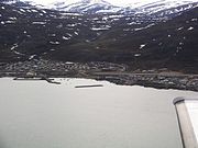
 Abeam the Pangnirtung Airport
-
 The town and airport snuggled in beside the mountains
-
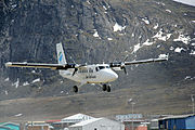
 Air Labrador de Havilland Canada DHC-6 Twin Otter on short final for runway 24
References
- Canada Flight Supplement. Effective 0901Z 16 July 2020 to 0901Z 10 September 2020.
- Synoptic/Metstat Station Information
- Total aircraft movements by class of operation
- Nunatsiaq News
- Full network schedule
External links
- Past three hours METARs, SPECI and current TAFs for Pangnirtung Airport from Nav Canada as available.
| Airports in Canada | |
|---|---|
| By name | |
| By location indicator | |
| By province/territory | |
| By area | |
| National Airports System | |
| Related | |
This article about an airport in Nunavut is a stub. You can help Misplaced Pages by expanding it. |