This is an old revision of this page, as edited by Daser23 (talk | contribs) at 20:19, 20 February 2023. The present address (URL) is a permanent link to this revision, which may differ significantly from the current revision.
Revision as of 20:19, 20 February 2023 by Daser23 (talk | contribs)(diff) ← Previous revision | Latest revision (diff) | Newer revision → (diff) Town in Transnistria, Moldova| Dnestrovsk
Днестро́вск Дністро́вськ | |
|---|---|
| Town | |
 | |
 Flag Flag Coat of arms Coat of arms | |
 | |
| Coordinates: 46°37′20″N 29°54′38″E / 46.62222°N 29.91056°E / 46.62222; 29.91056 | |
| Country (de jure) | |
| Country (de facto) | |
| Elevation | 19 m (62 ft) |
| Population | |
| • Total | 10,436 |
| Climate | Cfb |
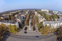
Dnestrovsk (Template:Lang-ro; Template:Lang-ru; Template:Lang-uk) is a town in southern Moldova, near the border with Ukraine. It is at the shores of the Cuciurgan Reservoir and is home to the Cuciurgan power station, also known as Moldavskaya GRES.
It is a company town which was founded in early Soviet times by the establishment of a large power plant, Moldavskaya GRES, today owned by Inter RAO UES.
At the 1989 census, Dnestrovsk has a population of 14,876. At the 2004 census it had ca. 11,200 inhabitants.
References
| Cities and towns of Moldova | ||
|---|---|---|
| Municipalities | ||
| Capitals of autonomous units | ||
| District seats | ||
| Other towns | ||
| In Transnistria. Controlled by the Transnistrian authorities. Also a municipality. The seat of Dubăsari District is the commune of Cocieri (not a city). | ||
46°37′N 29°55′E / 46.617°N 29.917°E / 46.617; 29.917
This Transnistria location article is a stub. You can help Misplaced Pages by expanding it. |
