This is an old revision of this page, as edited by R Lowry (talk | contribs) at 00:56, 23 January 2004. The present address (URL) is a permanent link to this revision, which may differ significantly from the current revision.
Revision as of 00:56, 23 January 2004 by R Lowry (talk | contribs)(diff) ← Previous revision | Latest revision (diff) | Newer revision → (diff)| Lancashire | |
 |
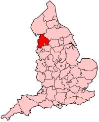
Lancashire is a county of England, lying on the Irish Sea.
The county borders Cumbria, North Yorkshire, West Yorkshire, Greater Manchester, and Merseyside, and the unitary authorities of Blackpool and Blackburn with Darwen.
The county before 1974 bordered Cumberland, Westmorland, Yorkshire, and Cheshire. A large part of Lancashire, surrounding Morecambe Bay, was removed. Blackpool and Blackburn with Darwen were districts of the county until the 1990s, when they were made independent.
Lancashire's population in 2000 was estimated as 1,429,450. Its name comes from Lancaster + shire.
Towns, cities, villages in Lancashire
Note: some of these places are no longer in Lancashire.
- Accrington, Adlington
- Bacup, Bamber Bridge, Barrow-in-Furness, Barnoldswick, Bickerstaffe, Blackburn, Blackpool, Bolton, Burnley, Burscough
- Carnforth, Chipping, Chorley, Clayton-le-Moors, Cleveleys, Clitheroe, Colne
- Dalton, Darwen
- Earby
- Fleetwood, Freckleton
- Galgate, Garstang, Gisburn, Goosnargh, Great Harwood
- Haslingden, Heysham, Hoghton
- Kirkham
- Lancaster, Lathom, Leyland, Liverpool, Longridge, Lytham
- Manchester, Mawdesley, Morecambe
- Nelson
- Ormskirk, Oswaldtwistle
- Padiham, Parbold, Pendle, Poulton-le-Fylde, Preston
- Rawtenstall, Ribchester, Rufford
- Silverdale, Skelmersdale, Slaidburn, St Annes
- Thornton, Trawden, Tyldesley
- Upholland
- Warrington, Whalley
Places of interest
- Astley Green Colliery Museum, Tyldesley
- Astley Hall
- British Commercial Vehicle Museum, Leyland
- East Lancashire Railway, a heritage railway
- Helmshore Textile Museum
- Hoghton Tower
- Samlesbury Hall
- Lathom Park Chapel, site of Lathom Hall, seat of the Earls of Derby
- Lancaster Castle
- Forest of Bowland
- Forest of Bowland AONB - Area of Outstanding Natural Beauty
- RSPB Leighton Moss nature reserve, Royal Society for the Protection of Birds
- WWT Martin Mere, Wildfowl and Wetlands Trust reserve, Burscough
- Wyre Forest NNR National Nature Reserve
- Leeds and Liverpool Canal, Ribble Link
- River Ribble, River Douglas, River Tawd, River Lostock, River Irwell, River Roch,
Historical Geography
The administrative area is an area rather smaller than that of the historic county as a result of the Local Government Act 1972. From April 1, 1974 the Furness area (the area of Lancashire north of Morecambe Bay) was given to the new county of Cumbria, the south east being given to Greater Manchester, and the south-west becoming Merseyside. Warrington town and surrounding districts including the villages of Winwick and Croft and Risley and Culcheth were annexed to Cheshire. A part of the West Riding of Yorkshire near Clitheroe, was transferred to Lancashire also.
Lancashire is divided into a number of local government districts. These are Chorley, Fylde, Hyndburn, Lancaster, Pendle, Preston, the Ribble Valley, Rossendale, South Ribble, West Lancashire, and Wyre.
External links
- Lancashire County Council - http://www.lancashire.gov.uk/
- Friends of Real Lancashire - http://www.forl.co.uk/