This is an old revision of this page, as edited by John Cardinal (talk | contribs) at 10:29, 8 February 2010 (Remove Mapit-US-cityscale, add coords to title, using AWB). The present address (URL) is a permanent link to this revision, which may differ significantly from the current revision.
Revision as of 10:29, 8 February 2010 by John Cardinal (talk | contribs) (Remove Mapit-US-cityscale, add coords to title, using AWB)(diff) ← Previous revision | Latest revision (diff) | Newer revision → (diff) For information about the shopping center of the same name, see Cherry Hill Mall (shopping mall). CDP in New Jersey, United States| Cherry Hill Mall, New Jersey | |
|---|---|
| CDP | |
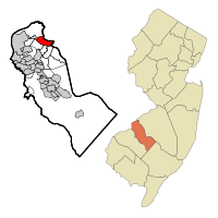
 Map of Cherry Hill Mall CDP in Camden County Map of Cherry Hill Mall CDP in Camden County | |
| Country | United States |
| State | New Jersey |
| County | Camden |
| Area | |
| • Total | 3.7 sq mi (9.6 km) |
| • Land | 3.7 sq mi (9.6 km) |
| • Water | 0.0 sq mi (0.0 km) |
| Elevation | 39 ft (12 m) |
| Population | |
| • Total | 13,238 |
| • Density | 3,581.8/sq mi (1,382.9/km) |
| Time zone | UTC-5 (Eastern (EST)) |
| • Summer (DST) | UTC-4 (EDT) |
| FIPS code | 34-12385Template:GR |
| GNIS feature ID | 1852605Template:GR |
Cherry Hill Mall CDP is a census-designated place and unincorporated area located within Cherry Hill Township, in Camden County, New Jersey. As of the United States 2000 Census, the CDP population was 13,238.
Geography
Cherry Hill Mall, New Jersey is located at 39°56′26″N 75°0′44″W / 39.94056°N 75.01222°W / 39.94056; -75.01222Invalid arguments have been passed to the {{#coordinates:}} function (39.940445, -75.012196)Template:GR.
According to the United States Census Bureau, the CDP has a total area of 9.6 km² (3.7 mi²), all land.
Demographics
As of the censusTemplate:GR of 2000, there were 13,238 people, 5,062 households, and 3,649 families residing in the CDP. The population density was 1,381.4/km² (3,581.8/mi²). There were 5,219 housing units at an average density of 544.6/km² (1,412.1/mi²). The racial makeup of the CDP was 83.15% White, 5.05% African American, 0.05% Native American, 9.03% Asian, 0.08% Pacific Islander, 1.10% from other races, and 1.54% from two or more races. Hispanic or Latino of any race were 3.01% of the population.
There were 5,062 households out of which 29.6% had children under the age of 18 living with them, 59.3% were married couples living together, 9.6% had a female householder with no husband present, and 27.9% were non-families. 24.0% of all households were made up of individuals and 12.5% had someone living alone who was 65 years of age or older. The average household size was 2.56 and the average family size was 3.05.
In the CDP the population was spread out with 22.5% under the age of 18, 5.5% from 18 to 24, 26.1% from 25 to 44, 25.4% from 45 to 64, and 20.5% who were 65 years of age or older. The median age was 42 years. For every 100 females there were 89.1 males. For every 100 females age 18 and over, there were 85.6 males.
The median income for a household in the CDP was $61,620, and the median income for a family was $69,441. Males had a median income of $51,118 versus $34,355 for females. The per capita income for the CDP was $28,892. About 3.6% of families and 4.8% of the population were below the poverty line, including 5.9% of those under age 18 and 3.9% of those age 65 or over.
The District
The District is a section of Cherry Hill with a high concentration of retail and dining entities. Inside The District contains the Cherry Hill Mall, shopping plazas, hotels, big box stores, dining amenities, and a large regional strip mall at the intersection of New Jersey Route 70 and Haddonfield Road. The District is located in the vicinity of New Jersey Route 38, Haddonfield Road, and New Jersey Route 70 and is within 20 minutes of Center City Philadelphia and Camden, New Jersey, although the area is prone to subsequently higher levels of traffic congestion during the rush hour periods as well as weekends.
References
| Municipalities and communities of Camden County, New Jersey, United States | ||
|---|---|---|
| County seat: Camden | ||
| Cities |  | |
| Boroughs | ||
| Townships | ||
| CDPs | ||
| Other unincorporated communities | ||
| Footnotes | ‡This populated place also has portions in an adjacent county or counties | |