This is an old revision of this page, as edited by Wolf 1 (talk | contribs) at 12:51, 30 June 2006. The present address (URL) is a permanent link to this revision, which may differ significantly from the current revision.
Revision as of 12:51, 30 June 2006 by Wolf 1 (talk | contribs)(diff) ← Previous revision | Latest revision (diff) | Newer revision → (diff)
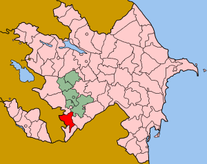
Qubadli (Qubadlı) is a rayon (i.e. an administration region) of Azerbaijan.
Qubadli is located on the south-western part of Azerbaijan, near Armenia and heads a district (rayon) of 802 sq. km that stretches along the border. The rayon comprises some pre-alpine landscape with very beautiful areas, in particular along the Vorotan and Hakari rivers. The entire district was lost to Armenian forces in 1993 and has remained under the control of the Nagorno Karabakh Defence Forces ever since. The population was moved west, part is spread across Azerbaijan but many still live in refugee camps near along the cease fire line.
Qubadli does not border the Nagorno Karabakh territory and is not claimed by the Armenians, as such it is currently occupied as part of their 'buffer zone' and left derelict and abandoned. The town has been "cannibalized" for all kinds of materials and is now in a sorry state. In the district several ruined Albanian churces and fortresses are worth a visit. (375 km south-west of Baku)
This Azerbaijan location article is a stub. You can help Misplaced Pages by expanding it. |