This is an old revision of this page, as edited by Golbez (talk | contribs) at 15:24, 2 August 2006 (→1800s: ... and add it here. note to self: update map). The present address (URL) is a permanent link to this revision, which may differ significantly from the current revision.
Revision as of 15:24, 2 August 2006 by Golbez (talk | contribs) (→1800s: ... and add it here. note to self: update map)(diff) ← Previous revision | Latest revision (diff) | Newer revision → (diff)This is a list of the evolution of the borders of the United States. It lists each change to the internal and external borders of the country.
Notes
- This list does not include unincorporated territories, such as Puerto Rico, Guam, and the United States Virgin Islands.
- "Unorganized territory" is not a name; it simply means that this territory has not had an organic act passed. In most situations, the purpose of unorganized territory was to act as land for Native American settlement. Later, the last unorganized territory in the country was indeed referred to as "Indian Territory", though this is not an official name.
- Dotted lines on the borders mean that region is part of a country not fully shown on the map, since it's confined to the present-day borders of the United States. An exception is Oregon Country, which extended beyond the area of the map.
- Many territorial disputes and borders from early in the United States' history are unclear. For example, the border between West Florida and East Florida seems unclear. For the purposes of simplicity, this article uses the original border, the Apalachicola River, even though later maps tended to move it west to the Perdido River. This is partly because the Organic Act for Florida specified that it included parts of both West and East Florida; if the border were the Perdido River, then Florida Territory would not have included any of West Florida, it having already been divided among Louisiana, Mississippi, and Alabama.
- Several very small changes are not included in these maps:
- The retrocession of land back to Virginia by the District of Columbia
- The resolution of the Northwest Angle in Minnesota
- The transfer of the Erie Triangle from New York to the federal government, then to Pennsylvania
- The transfer of the Toledo Strip from Michigan to Ohio
- Various disputes along the Rio Grande with Mexico.
- The Alaska Boundary Dispute, since it arose from a total lack of surveying, rather than a dispute over the surveyed lines; it would also appear quite small on the map.
1780s-1790s
The United States Constitution came in to effect, forming the new nation. Note that the states ratified at different times, but to simplify the map, the final result is shown here.
Some peculiarities to point out to those familiar only with the current borders: Many states had sea-to-sea grants from the British crown that they would not give up easily, so they ceded this land to the federal government in exchange for their Revolutionary War debts. However, Georgia did not do so until much later; Connecticut ceded most land but kept its Western Reserve; Virginia ceded its claim to the territory north and west of the Ohio River; and North Carolina ceded its claim to its western counties. The last two are shown on this map as unorganized territory. West Florida claimed a border higher than what the United States said it had; when the British held it, the border had been raised to 32°38' latitude, but when they ceded it back to Spain in the Treaty of Paris, they used the original border, the 31st parallel. West Florida continued to claim the higher border. Also, the borders at the northern area of the Maine District of Massachusetts, and the area northwest of Lake Huron, remained disputed.
The unorganized lands were organized into the Territory North West of the Ohio River, or Northwest Territory, and the Territory South West of the Ohio River, or Southwest Territory.

The Vermont Republic was admitted as the 14th state, Vermont.
The District of Columbia was formed from land granted by Maryland and Virginia; the Virginia portion would later be returned.
The western counties of Virginia were split and quickly admitted as the 15th state, Kentucky.

Pinckney's Treaty, also known as the Treaty of San Lorenzo, settles the northern border of West Florida as the 31st parallel.

The Southwest Territory was admitted as the 16th state, Tennessee.

The United States found that it does not hold Georgia's western claims valid, and created Mississippi Territory in the land ceded by West Florida.
1800s

Indiana Territory was formed from the western portion of Northwest Territory.
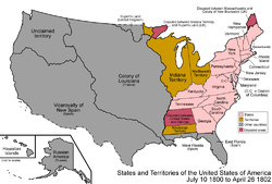
Connecticut ceded its Western Reserve to the federal government, which made it part of Northwest Territory.

Georgia finally ceded its western claims, the Yazoo Lands, to the federal government, as unorganized land. Also, on October 1 1800, the Third Treaty of San Ildefonso transferred the colony of Louisiana from Spain to France.
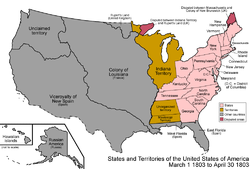
The southeastern portion of Northwest Territory was admitted as the 17th state, Ohio. The remainder of Northwest Territory was transferred to Indiana Territory. (Note that Congress did not pass a resolution formally admitting Ohio; while this was not required, this was retroactively remedied on August 7 1953.)

The Louisiana Purchase was made, doubling the country's size. There was a dispute with West Florida over how much land east of the Mississippi River it included. The purchase extended slightly north of the modern borders, as it was defined only as the watershed of the Mississippi River.
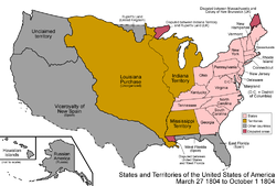
The unorganized land ceded by Georgia was added to Mississippi Territory.
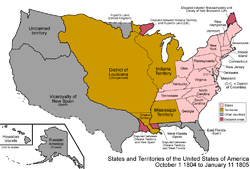
The Louisiana Purchase was split into the District of Louisiana, which was under the authority of Indiana Territory, and the organized Orleans Territory. The western border of Orleans Territory caused further conflict with New Spain over which river was the western boundary of the Purchase.

Michigan Territory was split from Indiana Territory, including the whole of the lower peninsula of present-day Michigan but only the portion of the upper peninsula held by the Northwest Territory after Indiana Territory had been split from it.

The District of Louisiana was organized as Louisiana Territory.
Illinois Territory was split from Indiana Territory. Indiana Territory includes the present-day borders of Indiana, plus the portion of the upper peninsula (and the Door Peninsula of present-day Wisconsin) that would fall within its borders if its western and eastern borders were continued northward.
1810s
The United States annexed the portion of West Florida that declared independence as the Republic of West Florida. Also, sometime during 1810, the Kingdom of Hawaii was formed.
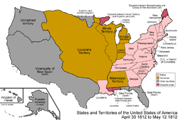
Orleans Territory was admitted as the 18th state, Louisiana.

The federal government added the newly-annexed land of West Florida to Mississippi Territory.
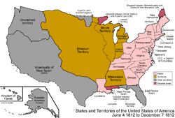
Louisiana Territory, having the same name as a state, was renamed to Missouri Territory.

Some sources indicate that the southern portion of Missouri Territory was made unorganized.
The southern portion of Indiana Territory was admitted as the 19th state, Indiana. The northern portion becomes unorganized.
Alabama Territory was split from Mississippi Territory.
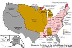
Mississippi Territory was admitted as the 20th state, Mississippi.

The Treaty of 1818 established the 49th parallel west of the Lake of the Woods as the border with British-held lands, and Oregon Country was established as a shared land between the United States and United Kingdom.

The southern portion of Illinois Territory was admitted as the 21st state, Illinois; the remainder was added to Michigan Territory.

The unorganized land south of Missouri Territory was organized as Arkansaw Territory.
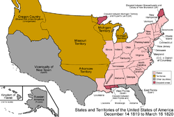
Alabama Territory was admitted as the 22nd state, Alabama.
1820s

The Maine District of Massachusetts was split off and admitted as the 23rd state, Maine.

The Adams-Onís Treaty came in to effect. It established the entirety of the border between the United States and New Spain. Under the terms of the treaty, both Floridas were also sold to the United States.

The southeastern portion of Missouri Territory was admitted as the 24th state, Missouri; the remainder became unorganized.

East Florida and the portion of West Florida not already part of other states were combined and organized as Florida Territory. Around this time, the official spelling of Arkansaw Territory (which had no real official spelling before) became Arkansas Territory. Also, on September 27 1821, the Viceroyality of New Spain achieved independence as Mexico.

Arkansas Territory was shrunk, the western portion becoming unorganized.

Arkansas Territory was shrunk further, the remainder again becoming unorganized.
1830s

A large portion of unorganized land was added to Michigan Territory.

The Republic of Texas achieved independence from Mexico, though with a large portion of the territory disputed.
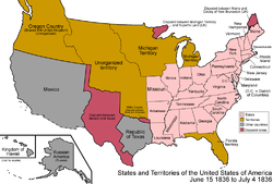
Arkansas Territory was admitted as the 25th state, Arkansas.
Wisconsin Territory was split off from Michigan Territory, leaving the latter only with the lower peninsula and a small portion of the upper peninsula.
As a consolation for giving up the Toledo Strip, the whole of the present-day upper peninsula was transferred from Wisconsin Territory to Michigan Territory.

Michigan Territory was admitted as the 26th state, Michigan.
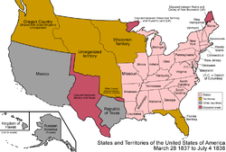
The Platte Purchase added a small area of land to Missouri, giving it its present-day boundaries.

Iowa Territory was split off from Wisconsin Territory.
1840s

The Webster-Ashburton Treaty settled the border between the United States and lands held by the United Kingdom east of the Rocky Mountains.

Florida Territory was admitted as the 27th state, Florida.

The Republic of Texas was annexed by the United States and admitted as the 28th state, Texas. It brought with it all the lands of Mexico that it claimed.

The Oregon Treaty established the 49th parallel west of the Lake of the Woods as the continental border (so it did not include Vancouver Island) with the lands held by the United Kingdom. The sharing of Oregon Country ended, and the American portion becomes unorganized territory.

The southeast portion of Iowa Territory was admitted as the 29th state, Iowa. The remainder became unorganized.

The Treaty of Guadalupe Hidalgo, ending the Mexican-American War, granted a large portion of land to the United States from Mexico.

The southeastern portion of Wisconsin Territory was admitted as the 30th state, Wisconsin. The remainder became unorganized.

Oregon Territory was organized.

Minnesota Territory was organized.
1850s
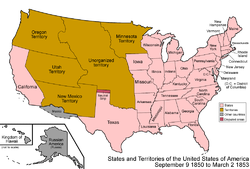
The Mexican Cession was divided. The western portion was admitted as the 31st state, California. The rest was organized as Utah Territory and New Mexico Territory. Both territories also included land ceded to the federal government by Texas; a portion of Texas and the Mexican Cession became unorganized land. A pecularity appeared at this time, when a small strip of land north of Texas was not officially claimed by any state or territory; this came to be called the Neutral Strip or "No Man's Land".

Washington Territory was split from Oregon Territory.

The Gadsden Purchase added some land to New Mexico Territory. At this time, the external borders of the continental United States became what they are today.

Nebraska Territory and Kansas Territory were organized; the remaining unorganized land colloquially became known as Indian Territory.
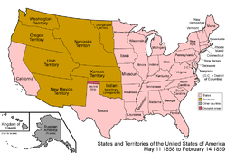
The eastern portion of Minnesota Territory was admitted as the 32nd state, Minnesota. The remainder became unorganized.
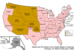
The western portion of Oregon Territory was admitted as the 33rd state, Oregon. The remainder was assigned to Washington Territory.
1860s

Texas began claiming Greer County, Texas, controlled at that time by the federal government as unorganized territory.
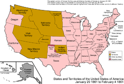
The eastern portion of Kansas Territory was admitted as the 34th state, Kansas. A pecularity arose for the western portion. It was added to Colorado Territory on February 28 1861; however, for the month between statehood for Kansas and the Colorado Territory being formed, it appears to have had no status. It was de facto under the control of the self-proclaimed Jefferson Territory.
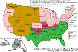
The Confederate States of America (CSA) was formed. The Southern states seceded at different dates and joined the CSA at different dates; to simplify the map, only the final form of the CSA is shown here. There were rebel governments as well as Union governments in Kentucky and Missouri, and the CSA had full control over Indian Territory.

Colorado Territory was organized, with land from Utah, New Mexico, and Nebraska Territories, as well as the land left over from Kansas Territory.

Dakota Territory was split from Nebraska Territory, and included the unorganized land left over from Minnesota Territory. Also, Nevada Territory was split from Utah Territory.
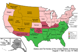
The Confederacy established Arizona Territory (CSA) in the southern half of the Union's New Mexico Territory. It would be organized on February 14 1862.

A strip of land on the western side of Utah Territory was transferred to Nevada Territory.
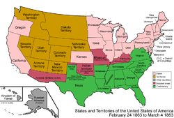
The Union created its own Arizona Territory, splitting it off from New Mexico Territory.

Idaho Territory was created from portions of Washington, Dakota, and Nebraska Territories.
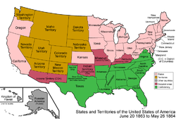
Several counties of northwestern Virginia who didn't want to be part of the Confederacy split off and were admitted as the 35th state. West Virginia.

Montana Territory was split from Idaho Territory, which also had some land transferred to Dakota Territory.
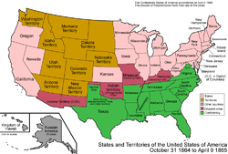
Nevada Territory was admitted as the 36th state, Nevada.

The Confederate States of America surrendered. The process of Reconstruction and readmission to the union would take several years; to simplify the map, they are shown as already readmitted.

A strip of Utah Territory's western land was transferred to the state of Nevada.

The northwestern corner of Arizona Territory was transferred to the state of Nevada, giving it its present-day borders.
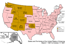
Nebraska Territory was admitted as the 37th state, Nebraska.

The United States purchased Alaska from Russia; it was designated the Department of Alaska.
1870s

Wyoming Territory was formed from portions of Dakota, Idaho, and Utah Territories.

Colorado Territory was admitted as the 38th state, Colorado.
1880s

The Department of Alaska was redesignated the District of Alaska.

Dakota Territory was split in two, and it was admitted as the 39th state, North Dakota, and 40th state, South Dakota.
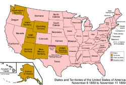
Montana Territory was admitted as the 41st state, Montana.

Washington Territory was admitted as the 42nd state, Washington.
1890s

Oklahoma Territory was organized from the western portion of Indian Territory, and it included the Neutral Strip.

Idaho Territory was admitted as the 43rd state, Idaho.
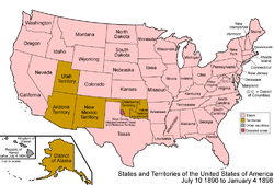
Wyoming Territory was admitted as the 44th state, Wyoming.

Utah Territory was admitted as the 45th state, Utah. Also of note, on July 4 1894, the Kingdom of Hawaii became the Republic of Hawaii.

A Supreme Court ruling officially assigns Greer County to Oklahoma Territory.

The Republic of Hawaii was annexed by the United States. It was organized in to the Territory of Hawaii on June 14 1900.
20th century

Oklahoma Territory and Indian Territory were combined and admitted as the 46th state, Oklahoma.

New Mexico Territory was admitted as the 47th state, New Mexico.

Arizona Territory was admitted as the 48th state, Arizona.
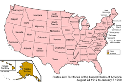
The District of Alaska was organized as Alaska Territory.

Alaska Territory was admitted as the 49th state, Alaska.

Hawaii Territory was admitted as the 50th state, Hawaii, resulting in the present-day situation of the United States.
See also
- List of U.S. states by date of statehood
- United States territorial acquisitions
- United States territory
- U.S. state