This is an old revision of this page, as edited by 79.67.69.99 (talk) at 20:47, 14 February 2019 (some content can be attributed to the arabian peninsula page). The present address (URL) is a permanent link to this revision, which may differ significantly from the current revision.
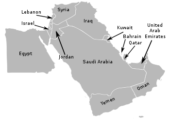
Revision as of 20:47, 14 February 2019 by 79.67.69.99 (talk) (some content can be attributed to the arabian peninsula page)(diff) ← Previous revision | Latest revision (diff) | Newer revision → (diff)File:Naher Osten.png|thumb|right|350px|Arabia colored in dark green]] Arabians are a narrower subset of Arabs, limited to inhabitants of the Arabian peninsula, and adjacent Arab-populated areas contiguous to it, particularly regions within the Arabian Plate such as Mashreq and the Levant.
Scope

In some sources, the term Arabia or Arabian pertains to the region and inhabitants thereof of the Arab world within southwest Asia. In a narrower sense, when it is used in the sense of the Arabian Peninsula and its inhabitants, particularly those along the Persian Gulf, it is used interchangeably with the term Khaleeji.
During the Arab revolt against the Ottoman empire, and for a few decades after its collapse, Arabia was often approximately characterized as constituting the region from the Arabian peninsula in the south up to a rough subcontinuous horizontal line along the coast between the Mediterranean and Anatolia.

Geography
Arabians, geologically, live in a region that may more appropriately be called the Arabian subcontinent because it lies on a tectonic plate of its own, the Arabian Plate, which has been moving incrementally away from the rest of Africa (forming the Red Sea) and north, toward Asia, into the Eurasian Plate (forming the Zagros Mountains). The rocks exposed vary systematically across Arabia, with the oldest rocks exposed in the Arabian-Nubian Shield near the Red Sea, overlain by earlier sediments that become younger towards the Persian Gulf. Perhaps the best-preserved ophiolite on Earth, the Semail Ophiolite, lies exposed in the mountains of the UAE and northern Oman.

History
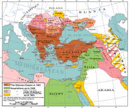
The provincial Ottoman Army for Arabia (Arabistan Ordusu) was headquartered in Syria, which included Palestine, the Transjordan region in addition to Lebanon (Mount Lebanon was, however, a semi-autonomous mutasarrifate). It was put in charge of Syria, Cilicia, Iraq, and the remainder of the Arabian Peninsula.

The Damascus Protocol of 1914 provides an illustration of the regional relationships. Arabs living in one of the existing districts of the Arabian peninsula, the Emirate of Hejaz, asked for a British guarantee of independence. Their proposal included all Arab lands south of a line roughly corresponding to the northern frontiers of present-day Syria and Iraq. They envisioned a new Arab state, or confederation of states, adjoining the southern Arabian Peninsula. It would have comprised Cilicia – İskenderun and Mersin, Iraq with Kuwait, Syria, Mount Lebanon Mutasarrifate, Jordan, and Palestine.
See also
References
- Zadok, Ran. "On Early Arabians in the Fertile Crescent." Tel Aviv 17.2 (1990): 223-231.
- Bosma, Ulbe, Leo Lucassen, and Jan Lucassen. "Migration and Colonial Enterprise in Nineteenth Century Java." Lucassen and Lucassen, Globalising Migration History (2014): 151-179.
- Brochu, Michael R. "Cyber Bullying: A Quantitative Study on the Perceptions and Experiences of Female Emirati University Students." (2017).
- Bayly, Christopher A. "Distorted Development: The Ottoman Empire and British India, circa 1780-1916." Comparative Studies of South Asia, Africa and the Middle East 27.2 (2007): 332-344.
- see History of the Ottoman Empire and Modern Turkey, Stanford J. Shaw, Ezel Kural Shaw, Cambridge University Press, 1977, ISBN 0-521-29166-6, page 85
- The Politics of Interventionism in Ottoman Lebanon, 1830–1861, by Caesar E. Farah, explains that Mount Lebanon was in the jurisdiction of the Arabistan Army, and that its headquarters was briefly moved to Beirut.
- As cited by R, John and S. Hadawi's, Palestine Diary, pp. 30–31, the 'Damascus Protocol' stated: "The recognition by Great Britain of the independence of the Arab countries lying within the following frontiers: North: The Line Mersin_Adana to parallel 37N. and thence along the line Birejek-Urga-Mardin-Kidiat-Jazirat (Ibn 'Unear)-Amadia to the Persian frontier; East: The Persian frontier down to the Persian Gulf; South: The Indian Ocean (with the exclusion of Aden, whose status was to be maintained). West: The Red Sea and the Mediterranean Sea back to Mersin. The abolition of all exceptional privileges granted to foreigners under the capitulations. The conclusion of a defensive alliance between Great Britain and the future independent Arab State. The grant of economic preference to Great Britain." see King Husain and the Kingdom of Hejaz, By Randall Baker, Oleander Press, 1979, ISBN 0-900891-48-3, pages 64–65