This is an old revision of this page, as edited by Crowsus (talk | contribs) at 18:31, 25 February 2020 (added Category:Bothwell and Uddingston using HotCat). The present address (URL) is a permanent link to this revision, which may differ significantly from the current revision.
Revision as of 18:31, 25 February 2020 by Crowsus (talk | contribs) (added Category:Bothwell and Uddingston using HotCat)(diff) ← Previous revision | Latest revision (diff) | Newer revision → (diff) For similar terms, see Hamilton (disambiguation).55°45′N 4°03′W / 55.75°N 4.05°W / 55.75; -4.05
| Hamilton | |
|---|---|
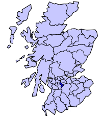
 Hamilton district within Scotland | |
| Population | |
| • 1994 | 105,202 |
| History | |
| • Created | 1975 |
| • Abolished | 1996 |
| • Succeeded by | (Part of) South Lanarkshire |
| Status | District |
| Government | Hamilton District Council |
| • HQ | Hamilton. |
Hamilton (Scottish Gaelic: Hamaltan) was a local government district in the Strathclyde region of Scotland from 1975 to 1996, lying to the south-east of the regional capital Glasgow.
Local Government
As its name suggests, the district (one of five in the Lanark sub-region and 19 overall across the Strathclyde region, which contained more than half of Scotland's population) was centred around the town of Hamilton, for several centuries the seat of the historic county of Lanarkshire, although its boundaries extended some way beyond the town. In the Local Government (Scotland) Act 1973 leading to its creation, the district's desired composition was described as:
- In the county of Lanark—the burgh of Hamilton; the Fourth district (except the electoral division of Avondale); in the Sixth district, the electoral divisions of Bothwell and Uddingston South, Uddingston North; in the Eighth district, the electoral divisions of Blantyre, Stonefield, and that part of High Blantyre electoral division lying outwith the designated area of East Kilbride New Town.
To the north of Hamilton, the district included the established adjoining villages of Uddingston and Bothwell, which constituted the only part of the district on the right bank of the River Clyde which otherwise formed its eastern boundary, and the mining town of Blantyre. To the south, the territory became increasingly rural, and included the towns of Larkhall and the villages of Ashgill and Stonehouse.
The Local Government etc. (Scotland) Act 1994 abolished all of the districts and regions. The territory was merged with the Clydesdale and East Kilbride districts and part of the Glasgow district to form the South Lanarkshire unitary council area, with the Hamilton District Council buildings used as the new SLC headquarters.
See also
References
- Hamilton, Undiscovered Scotland
- "New Local Government areas". Hansard. 22 October 1973. Retrieved 21 February 2020.
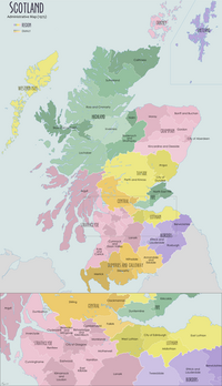
| Local government areas of Scotland, in use 1975 to 1996 | ||
|---|---|---|
| Borders |  | |
| Central Region | ||
| Dumfries and Galloway | ||
| Fife | ||
| Grampian | ||
| Highland | ||
| Lothian | ||
| Strathclyde | ||
| Tayside | ||
| Island areas | ||
| The island areas were unitary authorities, combining the powers of a region and a district. | ||
This South Lanarkshire location article is a stub. You can help Misplaced Pages by expanding it. |