This is an old revision of this page, as edited by Nomoskedasticity (talk | contribs) at 13:17, 17 February 2015 (Source doesn't meet WP:RS -- this is equivalent to an unmoderated blog site). The present address (URL) is a permanent link to this revision, which may differ significantly from the current revision.
Revision as of 13:17, 17 February 2015 by Nomoskedasticity (talk | contribs) (Source doesn't meet WP:RS -- this is equivalent to an unmoderated blog site)(diff) ← Previous revision | Latest revision (diff) | Newer revision → (diff)32°6′24″N 35°07′2″E / 32.10667°N 35.11722°E / 32.10667; 35.11722
| This article needs additional citations for verification. Please help improve this article by adding citations to reliable sources. Unsourced material may be challenged and removed. Find sources: "Barkan Industrial Park" – news · newspapers · books · scholar · JSTOR (February 2015) (Learn how and when to remove this message) |

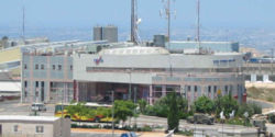
The Barkan Industrial Park (Template:Lang-he, lit. Barkan Industrial Area) is located about 25 kilometres east of Tel Aviv on the Israeli-occupied West Bank whose offices are located at the northern entrance. The industrial park is located adjacent to the Israeli settlement Barkan and near the settlement and city of Ariel.
Founded in 1982, the industrial park currently includes about 120 businesses and factories manufacturing plastics, metal-work, food, textile, and more.
Factory owners there say that calls to boycott some factories endanger employment for many Palestinians.
References
- "'Palestinians will lose jobs if boycott persists'". 20 May 2012.
External links
This geography of Israel article is a stub. You can help Misplaced Pages by expanding it. |