This is an old revision of this page, as edited by FromCzech (talk | contribs) at 12:28, 3 January 2025 (page created). The present address (URL) is a permanent link to this revision, which may differ significantly from the current revision.
Revision as of 12:28, 3 January 2025 by FromCzech (talk | contribs) (page created)(diff) ← Previous revision | Latest revision (diff) | Newer revision → (diff) River in Vysočina, Czech Republic| Šlapanka | |
|---|---|
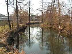
 The Šlapanka near estuary The Šlapanka near estuary | |
| Location | |
| Country | Czech Republic |
| Region | Vysočina |
| Physical characteristics | |
| Source | |
| • location | Kamenice, Křižanov Highlands |
| • elevation | 595 m (1,952 ft) |
| Mouth | |
| • location | Sázava |
| • coordinates | 49°36′2″N 15°35′42″E / 49.60056°N 15.59500°E / 49.60056; 15.59500 |
| • elevation | 410 m (1,350 ft) |
| Length | 39.0 km (24.2 mi) |
| Basin size | 264.8 km (102.2 sq mi) |
| Discharge | |
| • average | 1.20 m/s (42 cu ft/s) 4.5 km before estuary |
| Basin features | |
| Progression | Sázava→ Vltava→ Elbe→ North Sea |
The Šlapanka is a river in the Czech Republic, a left tributary of the Sázava River. It flows through the Vysočina Region. It is 39.0 km (24.2 mi) long.
Etymology
The river is named after the village of Šlapanov, located on the middle course of the river.
Characteristic

The Šlapanka originates in the territory of Kamenice in the Křižanov Highlands at an elevation of 595 m (1,952 ft) and flows to Havlíčkův Brod, where it enters the Sázava River at an elevation of 410 m (1,350 ft). It is 39.0 km (24.2 mi) long. Its drainage basin has an area of 264.8 km (102.2 sq mi).
The longest tributaries of the Šlapanka are:
| Tributary | Length (km) | Side |
|---|---|---|
| Zlatý potok | 20.3 | left |
| Ochozský potok | 10.5 | right |
| Skrýšovský potok | 9.9 | right |
| Zhořský potok | 9.1 | right |
Course
The river flows through the municipal territories of Kamenice, Věžnice (Jihlava District), Vysoké Studnice, Rybné, Kozlov, Jamné, Ždírec, Věžnička, Polná, Věžnice (Havlíčkův Brod District), Šlapanov, Vysoká, Bartoušov and Havlíčkův Brod.
Bodies of water
A system of three fishponds (Peklo, Bor and Kukle) is built on the middle course of the Šlapanka. The largest of them is Peklo, located inside the built-up area of the town of Polná. It was founded in 1479–1482 and has an area of 16 ha (40 acres).
See also
References
- ^ "Vodní toky". Evidence hlásných profilů (in Czech). Czech Hydrometeorological Institute. Retrieved 2025-01-03.
- "I.2.1a Útvary povrchových vod kategorie "řeka"" (PDF) (in Czech). Povodí Vltavy, s.p. Retrieved 2024-01-03.
- "6. rybník Peklo" (in Czech). Czech Tourist Club in Polná. Retrieved 2024-01-03.
External links
- River flow at Mírovka station – Flood Warning and Forecasting Service of the Czech Hydrometeorological Institute