This is an old revision of this page, as edited by MRSC (talk | contribs) at 21:29, 25 May 2005 (-line break). The present address (URL) is a permanent link to this revision, which may differ significantly from the current revision.
Revision as of 21:29, 25 May 2005 by MRSC (talk | contribs) (-line break)(diff) ← Previous revision | Latest revision (diff) | Newer revision → (diff)- Mile End is also a neighbourhood in Montreal.
| Mile End | |
|---|---|
| OS Grid Reference: | TQ365825 |
| Administration | |
| Borough: | Tower Hamlets |
| County: | Greater London |
| Region: | Greater London |
| Nation: | England |
| Other | |
| Ceremonial County: | Greater London |
| Traditional County: | Middlesex |
| Post Office and Telephone | |
| Postal County: | LONDON |
| Postcode: | E3 |
| Dialling Code: | 020 |
Mile End is an area of the London Borough of Tower Hamlets in East London. Mile End is 3.6 miles (5.8 km) east north-east of Charing Cross.
It is in a part of London known as the East End and home to the main campus of Queen Mary, University of London.
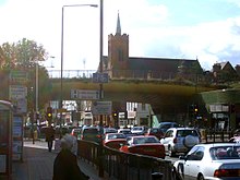
It also boasts an unusual landmark, the "Green Bridge". This new structure (completed in about 2000) allows Mile End Park to cross over the road and makes an interesting contrast with the more usual approach of building bridges for cars. It contains garden and water features and some shop and restaurant space built in below.
Nearest places:
Nearest tube stations:

This London location article is a stub. You can help Misplaced Pages by expanding it. |