This is an old revision of this page, as edited by Spellcast (talk | contribs) at 14:44, 31 May 2009 (afd). The present address (URL) is a permanent link to this revision, which may differ significantly from the current revision.
Revision as of 14:44, 31 May 2009 by Spellcast (talk | contribs) (afd)(diff) ← Previous revision | Latest revision (diff) | Newer revision → (diff)| An editor has nominated this article for deletion. You are welcome to participate in the deletion discussion, which will decide whether or not to retain it.Feel free to improve the article, but do not remove this notice before the discussion is closed. For more information, see the guide to deletion. Find sources: "Geography of the Former Republic of Serbian Krajina" – news · newspapers · books · scholar · JSTOR%5B%5BWikipedia%3AArticles+for+deletion%2FGeography+of+the+Former+Republic+of+Serbian+Krajina%5D%5DAFD |
| This article has no lead section. Please improve this article by adding one in your own words. (December 2008) (Learn how and when to remove this message) |

Republic of Serbian Krajina shown in red
Physical Geography
The former Republic of Serbian Krajina's landscape was very rugged and mountainous. Some of the entity did have pastures, and this was mainly along some rivers and in the east. The Sava river was a border. The maintain range in the entity was the Dinaric alps, the main subsections of that being: Petrova Gora, Zrinska Gora, Mala Kapela; the highest peak was Dinara, though the size of the area did change as the Serbian army gained control of more land in Croatia, until finally defeated in August 1995.
List of towns
List of towns in the former Republic of Serbian Krajina:
|
Population geography

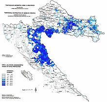
By the start of the 1990s and before the war, about two thirds of the Krajina (later UNPA zones North and South- not Western or Eastern Slavonia) population was Serb. These Serbs accounted for about 29% of the total Serb population in the then-SR Croatia (and in turn the ethnic Serb population accounted for about 12.2% of the total population of SR Croatia). The increase in ethnic tensions caused the demographic proportions to shift markedly even before the fighting broke out.
The official census held in the spring of 1991, just before the war began, is recorded in Republic of Croatia statistics books, but not currently available online. Hence, there are two different sources for pre-war population distribution: the ICTY indictment against Milošević, given in the 1st table below, and the official Croatian data excerpted from the books, presented in the 2nd table.
The allocation of the population in the different parts of the RSK was, according to the ICTY source, as follows:
| UNPA Zones North and South |
UNPA Sector West |
UNPA Sector East |
Total |
|---|---|---|---|
| 168,437 (67%) Serbs 70,708 (28%) Croats 13,101 (5%) others |
14,161 (60%) Serbs 6,864 (29%) Croats 2,577 (11%) others |
61,492 (32%) Serbs 90,454 (47%) Croats 40,217 (21%) others |
244,090 (52.15%) Serbs 168,026 (35.9%) Croats 55,895 (11.94%) others |
| (Source: ICTY) |
However, the cited figures differ from those published in official Croatian census, which gives the following data:
| UNPA Zones North and South |
UNPA Sector West |
UNPA Sector East |
Total |
|---|---|---|---|
| 169,906 (66.7%) Serbs 69,646 (28%) Croats 13,183 (5.5%) others |
35,206 (35.4%) Serbs 43,063 (43.3%) Croats 21,183 (21.3%) others |
57,208 (30.4%) Serbs 92,398 (49.1%) Croats 35,578 (20.5%) others |
258,320 (48.16%) Serbs 205,107 (38.24%) Croats 72,944 (13.6%) others |
Both calculations does not include "pink zones" (zones outside UNPA, but inside RSK). These zones are usually with much bigger percentage of Serbs than UNPA zones. Examples of rose zones include Medak, Vrlika, Lički Osik ("Teslingrad"), Vrhovine, and Plaski. The largest discrepancy is in the UNPA Sector West, which might refer to the fact that this zone originally included large patches of western Slavonia (areas around Grubišno Polje, Daruvar, Pakrac and the western slopes of Papuk), but these weren't controlled by the RSK in the later stages of the war.
During the period when the RSK was formed, it was difficult to determine the exact population due to the war situation. Many Serb refugees from elsewhere in Croatia and Bosnia settled in Serb-occupied Krajina while many Croats were forced to flee, and a steady stream of people left the region to escape its pervasive poverty.
According to a local census by the RSK authorities from 1993, there were 480,000 residents: 91% Serbs (433,595), 7% Croats and 2% others. In 1994, the RSK's government estimated the population at 430,000 people. The apparent fall in the population may have been due to the general systematic expulsions outweighing the intake of Serbs from elsewhere. On the other hand, Croatian authorities hold these figures to be a pure morale-boosting fiction; the number of Serbs (virtually all of the population) who fled Eastern Slavonia and UNPA zones North and South in 1995 have been estimated by UN authorities to range between 150,000-200,000 people. Since the sector East did not account, after ethnic cleansing, for more than 50,000-70,000 inhabitants, the entire RSK population, as estimated by Croatian authorities, oscillated somewhere between 200,000 and 250,000.