This is an old revision of this page, as edited by 216.130.73.82 (talk) at 02:58, 9 December 2009. The present address (URL) is a permanent link to this revision, which may differ significantly from the current revision.
Revision as of 02:58, 9 December 2009 by 216.130.73.82 (talk)(diff) ← Previous revision | Latest revision (diff) | Newer revision → (diff) Hamlet in Nunavut, Canada| Kugluktuk
Qurluqtuq ᖁᕐᓗᖅᑐᖅ Template:Location map polarx | |
|---|---|
| Hamlet | |
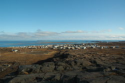
 Hill top view of Kugluktuk Hill top view of Kugluktuk | |
| Country | |
| Territory | |
| Region | Kitikmeot Region |
| Electoral district | Kugluktuk |
| Government | |
| • Mayor | Allen Niptanatiak |
| • MLA | Peter Taptuna |
| Area | |
| • Total | 549.61 km (212.21 sq mi) |
| Elevation | 23 m (75 ft) |
| Population | |
| • Total | 1,302 |
| • Density | 2.4/km (6.1/sq mi) |
| Time zone | UTC-7 (MST) |
| • Summer (DST) | UTC-6 (MDT) |
| Canadian Postal code | X0B 1K0 |
| Area code | 867 |


Kugluktuk (Inuinnaqtun: Qurluktuk, "the place of moving water"; Inuktitut: ᖁᕐᓗᖅᑐᖅ, formerly Coppermine until 1 January 1996) is a hamlet located at the mouth of the Coppermine River in the Kitikmeot Region of Nunavut, Canada, on Coronation Gulf, southwest of Victoria Island. It is the westernmost community in Nunavut, almost on the border with the Northwest Territories.
The traditional language of the area was Inuinnaqtun and is written using the Latin alphabet rather than the syllabics of the Inuktitut writing system. Like Cambridge Bay, Bathurst Inlet and Umingmaktok syllabics are rarely seen and used mainly by the Government of Nunavut.
Location
The community has the usual services, a post office, Northern Store, co-op store, and Hunters & Trappers Association. The entire town is covered by wireless Internet service. There are two schools, the Kugluktuk High School and the Jimmy Hikok Ilihakvik. In June 2004, a fuel line broke in the center of Kugluktuk, spilling 2,000 L (439.9 imp gal; 528.3 US gal) of diesel fuel.
Demographics
As of the 2006 census the population was 1,302 an increase of 7.4% from the 2001 census.
Geography
Kugluktuk is located on the shore of the Arctic Ocean. The surrounding landscape is dominated by the rocky and often barren Canadian Shield. The region has a semi-arid Arctic climate, with very cold winters, light snowfall, and summers too cool to permit the growth of trees. Though trees do exist in the region, they are dwarfed and extremely sparse.
Flora and fauna
Plant growth in the region during summer months includes small shrubs, grass, moss, lichens, blueberries, blackberries, cranberries, various flowers, and dwarfed pine and birch trees.
Climate
| Climate data for Kugluktuk | |||||||||||||
|---|---|---|---|---|---|---|---|---|---|---|---|---|---|
| Month | Jan | Feb | Mar | Apr | May | Jun | Jul | Aug | Sep | Oct | Nov | Dec | Year |
| Source: Environment Canada | |||||||||||||
See also
- Kugluk/Bloody Falls Territorial Park
- Bloody Falls Massacre
- Bloody Falls
- Kugluktuk Airport
- Joe Allen Evyagotailak
- Donald Havioyak
- Lena Pedersen
- Kangiryuatjagmiut
- Kangiryuarmiut
References
- Hamlets elect new councils
- Election Results - 2008 General Election
- ^ 2006 census
- Elevation at airport. Canada Flight Supplement. Effective 0901Z 16 July 2020 to 0901Z 10 September 2020.
- Environment Canada—Canadian Climate Normals 1971–2000, accessed 14 July 2009
- Office of the Languages Commissioner of Nunavut - PDF Dialect Map
- Office of the Languages Commissioner of Nunavut - Writing systems
Further reading
- Dredge, L. A. Where the river meets the sea geology and landforms of the lower Coppermine River Valley and Kugluktuk, Nunavut. : Geological Survey of Canada, 2001. ISBN 0660185504
- Pedersen, Lena, and Donna Stephania. Crime Prevention in Kugluktuk. Ottawa: Caledon Institute of Social Policy, 1999. ISBN 1894159616