This is an old revision of this page, as edited by Amerique (talk | contribs) at 01:51, 2 February 2010 (pruning boosterism and other cruft. No evidence that "Greater San Bernardino" as used in the references refers to the valley. All the content removed is available in the articles linked to.). The present address (URL) is a permanent link to this revision, which may differ significantly from the current revision.
Revision as of 01:51, 2 February 2010 by Amerique (talk | contribs) (pruning boosterism and other cruft. No evidence that "Greater San Bernardino" as used in the references refers to the valley. All the content removed is available in the articles linked to.)(diff) ← Previous revision | Latest revision (diff) | Newer revision → (diff)
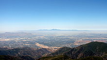
The San Bernardino Valley lies at the south base of the Transverse Ranges. It is bordered on the north by the eastern San Gabriel Mountains and San Bernardino Mountains, on the east by the San Jacinto Mountains, and on the south and west by the Santa Ana Mountains and Pomona Valley. Elevation varies from 180 metres (590 ft) on valley floors near Chino, where it gradually increases to about 420 metres (1,380 ft) near San Bernardino and Redlands. The valley floor houses roughly over 80% of the over 4 million total human population in the Inland Empire region, one of the most important industrial and residential areas of Southern California and the 14th largest metropolitan area in the United States.
History
The San Bernardino Valley was originally inhabited by Native Americans including the Serrano Tribe. Early colonization was done by Mormons, who still have a sizable presence in the area.

Geography
The San Bernardino Valley was cut from fast moving water flows from mountain ranges in the north, east and south that collectively drain into the Santa Ana River basin that goes to the sea through Riverside and Orange County. The valley connects several open natural areas and beautiful mountain and valley vistas. The San Bernardino Valley is surrounded by preserves, national forests and open recreational areas. For this reason many residents travel through the area for a variety of outdoor sports, including skiing, hiking, biking and ballooning in the mountain resorts of Crestline, Lake Arrowhead and Big Bear City.
Once part of famed U.S. Route 66, it is now crossed by Interstate 15 on its way through the high desert. Interstate 10 enters the valley from Pomona and exits to the east over the San Gorgonio Pass, which enters into the low desert.
Joan Didion, in her essay "Some Dreamers of the Golden Dream," describes the San Bernardino Valley as "...in certain ways an alien place: not the coastal California of the subtropical twilights and the soft westerlies of the Pacific but a harsher California, haunted by the Mojave just beyond the mountains, devastated by the hot dry Santa Ana wind that comes down through the passes at 100 miles an hour and works on the nerves."
Climate

The climate is Mediterranean with cool to cold, wet, in some cases snowy winters (extreme east and north valley areas) and dry, hot summers. Usually the areas north of interstate 210 and east of interstate 215 see colder weather in the winter with occasional snowfall. Sage scrub and the Yucca plant are the predominant natural vegetation along washes and uplands; it intergrades with chaparral at elevations of 600 to 700 m. Other vegetation consists of a patchwork of grasslands, riparian woodlands, and mixed hardwood forests, which border the valley in the mountains on the north and east. The Santa Ana winds blow into the valley from the Cajon Pass, which exits the valley's north end between the San Gabriel and San Bernardino mountains. The seasonal Santa Ana winds are felt particularly strongly in the San Bernardino area as warm and dry air is channeled through nearby Cajon Pass at times during the autumn months. This phenomenon markedly increases the wildfire danger in the foothill, canyon, and mountain communities that the cycle of cold wet winters and dry summers helps create.
| Monthly Normal High and Low Temperatures for San Bernardino | |||||||||||||
| Month | Jan | Feb | Mar | Apr | May | Jun | Jul | Aug | Sep | Oct | Nov | Dec | Year |
|---|---|---|---|---|---|---|---|---|---|---|---|---|---|
| Avg high °F | 62 | 66 | 68 | 71 | 77 | 91 | 102 | 103 | 89 | 80 | 71 | 64 | 75 |
| Avg low °F | 34 | 35 | 41 | 46 | 50 | 53 | 60 | 60 | 57 | 50 | 42 | 37 | 46 |
National Forests
Although not in the valley, the San Bernardino Mountains attract much tourism to the valley as people drive up to the local resorts, especially in the winter months. A famous ski resort in the area is Big Bear. Other famous mountain communities with large tourism include Lake Arrowhead, Big Bear Lake, and Crestline.
National forests surrounding the high valley include the Cleveland National Forest and the San Bernardino National Forest.
See also
Gallery
- San Bernardino skyline San Bernardino skyline
-
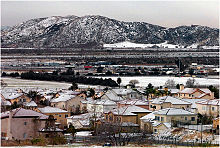
 Juncture of the San Gabriel and San Bernardino Mountains. The I-210 (Foothill Expressway) runs parallel, I-215 intersects leading to the Cajon Pass.
-
 Artificial color image of smoke from Oct 2003 wildfires covering the Greater San Bernardino Area
References
- Hall, Clarence A. (2007-10-07). Introduction to the geology of southern California and its native plants. University of California Press. p. 173. ISBN 0520249321, 9780520249325.
{{cite book}}: Check|isbn=value: invalid character (help) - Powell, Robert E. (1993). The San Andreas fault system. Geological Society of America. pp. vii, 5, 150, 151. ISBN 0813711789, 9780813711782.
{{cite book}}: Check|isbn=value: invalid character (help); Unknown parameter|coauthors=ignored (|author=suggested) (help) - ^ Mian, Lal S. (December, 2000), Inland Empire Environmental Quality Paradigm (PDF), San Bernardino: California State University, San Bernardino, Department of Health Science and Human Ecology, retrieved 2007-12-16
{{citation}}: Check date values in:|date=(help) - ^ Davis, Liam H. (1998). "History and Status of the California Gnatcatcher in San Bernardino County" (PDF). Western Birds. 29 (4). Organization of Western Field Ornithologists: 361–365. Retrieved 2007-12-17.
{{cite journal}}: Unknown parameter|coauthors=ignored (|author=suggested) (help) - Water Resources Institute, California State University, San Bernardino (2004), The Santa Ana River and Watershed Bibliography (PDF), Redlands: Redlands Institute, University of Redlands, retrieved 2007-12-17
{{citation}}: CS1 maint: multiple names: authors list (link) - Didion, Joan (1968), "Some Dreamers of the Golden Dream", Slouching Towards Bethlehem: Essays, New York: Farrar, Straus and Giroux
- Weatherbase. San Bernardino Valley
- San Bernardino National Forest. San Bernardino National Forest
34°4′N 117°17′W / 34.067°N 117.283°W / 34.067; -117.283
| Inland Empire | |
|---|---|
| Counties | |
| Principal cities | |
| Cities and towns 100k+ | |
| Cities and towns 25k–100k | |
| Cities and towns 10k–25k | |
| Cities and towns under 10k | |
| Regions | |
| Topics |  | ||||
|---|---|---|---|---|---|
| History | |||||
| Areas | |||||
| Transportation |
| ||||
| Points of interest | |||||
| Education |
| ||||
| Sports | |||||