This is an old revision of this page, as edited by TodorBozhinov (talk | contribs) at 16:25, 9 February 2010 (Reverted 1 edit by SunnieBG; Rv, unjustified. (TW)). The present address (URL) is a permanent link to this revision, which may differ significantly from the current revision.
Revision as of 16:25, 9 February 2010 by TodorBozhinov (talk | contribs) (Reverted 1 edit by SunnieBG; Rv, unjustified. (TW))(diff) ← Previous revision | Latest revision (diff) | Newer revision → (diff)42°17′N 22°41′E / 42.283°N 22.683°E / 42.283; 22.683
Place in Bulgaria| Kyustendil Кюстендил | |
|---|---|
| File:Around kyustendil galleryfull.jpg | |
 Coat of arms Coat of arms | |
| Country | |
| Province (Oblast) | Kyustendil |
| Government | |
| • Mayor | Petar Paunov |
| Elevation | 513 m (1,683 ft) |
| Population | |
| • Total | 51,872 |
| Time zone | UTC+2 (EET) |
| • Summer (DST) | UTC+3 (EEST) |
| Postal Code | 2500 |
| Area code | 078 |
| License plate | KH |
Kyustendil (Template:Lang-bg, historically Велбъжд, Velbazhd) is a town in the far west of Bulgaria, the capital of Kyustendil Province, with a population of 58,059 (2005 census). Kyustendil is situated in the southern part of the Kyustendil Valley, 90 km southwest of Sofia. It was named after the medieval lord of the surrounding region, Constantine Dragaš.
Geography
Kyustendil is a national balneological resort at an altitude of 500 metres. The ancient name of the town, Pautalia (a town of springs) is Thracian.
There are more than 40 mineral springs in the town. The waters have a high content of sulfite compounds. These are used for the treatment of the locomotory system, gynecological and other kinds of diseases. The resort region includes several baths, balneological complexes and others.
Kyustendil is located at the foot of the Osogovo mountain, on both banks of the Banska River and is a well-known centre of balneology and fruit growing. The town is 90 kilometres southwest of Sofia, 69 km northwest of Blagoevgrad and 22 km from the border with the Republic of Macedonia. The fortress was built by the Romans. Thermae, basilicas, floor mosaics have been uncovered.
History
A Thracian settlement was founded at the place of the modern town in the 5th-4th century BC and the Romans developed it into an important stronghold, balneological resort and trade junction called Pautalia in the 1st century AD.
The Hisarlaka fortress was built in the 4th century and the town was mentioned under the Slavic name of Velbazhd (Велбъжд, meaning "camel") in a 1019 charter by the Byzantine Emperor Basil II. It became a major religious and administrative centre.

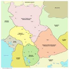
During the reign of Kaloyan of Bulgaria, the town became part of the Second Bulgarian Empire, acquiring its modern name in the 16th century, named after local feudal lord Konstantin Dragash (ruled from 1379 to 1395). In 1330 the Battle of Velbazhd took place in the vicinity of the town. After that war, the city came under Serbian rule, which lasted between 1330-1355. About 1355 Velbazhd and its region were included in the semi-independent feudal Velbazhd principality of Despot Deyan. In 1372 the Turks conquered the town. It was known as Köstendil under Ottoman rule. The name Köstendil was derived from Constantine Dragas' name. The city was a sanjak centre initially in Rumelia province, after that in the Bitola and Niš vilayets. It was a kaza centre in the Sofia sanjak of Danube Province until the creation of the Principality of Bulgaria in 1878.
The residents of Kyustendil took an active part in the Bulgarian National Revival and crafts and trade flourished. The town was liberated from Ottoman rule on 29 January 1878.
International relations
Main article: List of twin towns and sister cities in BulgariaTwin towns — Sister cities
Kyustendil is twinned with:
Honour
Pautalia Glacier on Livingston Island in the South Shetland Islands, Antarctica is named after Pautalia (the Thracian name for the settlement).
Notable people
- Constantine Dragaš, 14th-century local ruler
- Ilyo Voyvoda (1805–1898), hajduk, revolutionary and Bulgarian liberation fighter (died in Kyustendil)
- Dimitar Peshev (1894–1973), World War II Minister of Justice who prevented the deportation of the Bulgarian Jews to Nazi death camps
- Todor Angelov (1900–1943), communist revolutionary and anti-fascist terrorist in Belgium
Gallery
-
 The municipality hall (architect Friedrich Grünanger)
-
 The municipality hall
-

-

- File:Around kyustendil galleryfull.jpg
-

-

-
-
Timber-framed tower
-
 10th-11th century Church of St George in the Kolusha neighbourhood
References
External links
- KnCity.info, a website about Kyustendil
- Kyustendil at Journey.bg
- Kyustendil at BGGlobe
- Regional History Museum
| Municipalities of Kyustendil Province | |
|---|---|

