This is an old revision of this page, as edited by Kwiki (talk | contribs) at 00:22, 17 May 2010 (clean up, typos fixed: Resturant → Restaurant (2) using AWB). The present address (URL) is a permanent link to this revision, which may differ significantly from the current revision.
Revision as of 00:22, 17 May 2010 by Kwiki (talk | contribs) (clean up, typos fixed: Resturant → Restaurant (2) using AWB)(diff) ← Previous revision | Latest revision (diff) | Newer revision → (diff) Suburb of Melbourne, Victoria, Australia| Chelsea Heights Melbourne, Victoria | |||||||||||||||
|---|---|---|---|---|---|---|---|---|---|---|---|---|---|---|---|
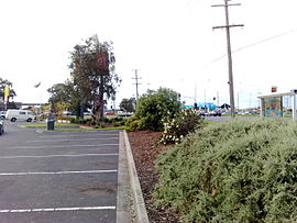
 Wells Road - Springvale Road Intersection view from the Chelsea Heights fast food outlets car park. Wells Road - Springvale Road Intersection view from the Chelsea Heights fast food outlets car park. | |||||||||||||||
| Population | 5125 (2006) | ||||||||||||||
| • Density | Lua error: Unable to convert population "5125 (2006)'"`UNIQ--ref-00000000-QINU`"'" to a number. | ||||||||||||||
| Postcode(s) | 3196 | ||||||||||||||
| Area | 3.2 km (1.2 sq mi) | ||||||||||||||
| Location | 32 km (20 mi) from Melbourne | ||||||||||||||
| LGA(s) | City of Kingston | ||||||||||||||
| State electorate(s) | Carrum | ||||||||||||||
| Federal division(s) | Isaacs | ||||||||||||||
| |||||||||||||||
Chelsea Heights is a suburb in Melbourne, Victoria, Australia, 30 km south-east from Melbourne's central business district. Its Local Government Area is the City of Kingston. At the 2006 Census, Chelsea Heights had a population of 5,125.
The suburb is home to Chelsea Heights Primary School, The Chelsea Heights Cricket & Football Club, Bonbeach Blue Jays Baseball Club.
It also contains a Doctor Surgery, McDonalds, KFC, Subway, 2 Fish & Chip Shops, Charcoal Chicken, Newsagent, 3 Pizza Shops, Milkbar, Blockbuster, 2 Hairdressers, Thai Restaurant, Chinese Restaurant, Post Office, Pura Milk Factory, Mitre 10 Mega, Toby Haden Swimming Pool, Chelsea Heights Pub, Dan Murphys Liquior Store, South East Holiday Village and a number of Factorys.
On the border of Chelsea Heights and Chelsea is the Bayside Trail bicycle track, which begins in Seaford and continues north for approximately 43 km to Port Melbourne.
Popular Reference
The aerial photography at the beginning of the Network 7 show Kath & Kim shows the central portion of Chelsea Heights.
See also
- City of Springvale - the former local government area of which Chelsea Heights was a part.
Famous resident - Shah Diron
References
- Australian Bureau of Statistics (25 October 2007). "Chelsea Heights (State Suburb)". 2006 Census QuickStats. Retrieved 2008-03-28.
- Chelsea Heights, accessed 28 March 2008
- Google Maps
External links
Template:Mapit-AUS-suburbscale
| Suburbs of the City of Kingston | |
|---|---|
^ = territory divided with another LGA |
This article about a place in Melbourne is a stub. You can help Misplaced Pages by expanding it. |