This is an old revision of this page, as edited by 67.72.98.45 (talk) at 07:32, 4 March 2006. The present address (URL) is a permanent link to this revision, which may differ significantly from the current revision.
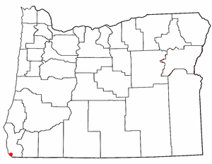
Revision as of 07:32, 4 March 2006 by 67.72.98.45 (talk)(diff) ← Previous revision | Latest revision (diff) | Newer revision → (diff)Brookings is a city located in Curry County, Oregon. It was named after John E. Brookings, president of the Brookings Lumber and Box Company, which founded the city in 1908. As of the 2000 census, the city had a total population of 5,447. As of 2005, Brookings had a population of over 6,000 within the city limits. The total population of the Brookings area is over 13,000, which includes Harbor, a CDP, and others. There have been numerous attempts to annex the unicorporated areas into Brookings. While most attempts failed over the years, one large area north of town owned by Borax has succeeded and in January 2006 the city approved another for a 607-acre parcel in the hills above Harbor. The city also annexed a 3.5-mile stretch of Highway 101 to connect to the new development. These new developments have the potential to add thousands of homes over the next 20 years, although developers expect many of them to be occupied only seasonally.
Due to its location, Brookings is subject to winter (and less frequently summer) temperatures considered unseasonably warm for the Oregon Coast. Temperatures can reach 70 to 80 degrees Fahrenheit (21 to 27 degrees Celsius) throughout the year. This is due in part to the marine influences from its location on the Pacific Ocean, but mostly from its situation at the foot of the Klamath Mountains, whose winds compress and warm the air flowing onto Brookings. This is called the Brookings effect or Chetco effect. But while area real estate agents and other unobjective sources have dubbed Brookings the "banana belt" of the Oregon coast, this is no Baja California. Heavy rain is common in the winter. Heavy fog is common in the summer.
History
While John E. Brookings was responsible for the founding of Brookings as a company town, it was his cousin Robert S. Brookings, who was responsible for its actual design. The latter Brookings hired Bernard Maybeck, an architect based in San Francisco who was later involved in the Panama-Pacific Exposition to lay out the plat of the townsite.
On September 9th, 1942, Mt. Emily, near Brookings, became the first site in the continental United States to suffer aerial bombardment in wartime. A Japanese floatplane piloted by Nobuo Fujita launched from submarine I-25 was loaded with incendiary bombs and sent to start massive fires in the dense forests of the Pacific Northwest. The attack caused only minor damage. Fujita would be invited back to Brookings in 1962 and he presented the town his family's 400-year old samurai sword in friendship after the Japanese government was given assurances that he would not be tried as a war criminal. Brookings made him an honorary citizen several days before his death in 1997.
Since the 1980s, Brookings has attracted retirees, largely from California, who have come to form a sizeable minority of the population. Their political influence is felt in routinely voting against new taxes. It is also home for a number of people who commute to jobs in California--mostly at nearby Pelican Bay State Prison.
Geography

Brookings is located at 42°3'27" North, 124°17'11" West (42.057474, -124.286415)Template:GR.
According to the United States Census Bureau, the city has a total area of 7.3 km² (2.8 mi²). 7.2 km² (2.8 mi²) of it is land and 0.1 km² (0.04 mi²) of it is water. The total area is 1.06% water.
Demographics
As of the censusTemplate:GR of 2000, there are 5,447 people, 2,309 households, and 1,484 families residing in the city. The population density is 753.8/km² (1,951.6/mi²). There are 2,614 housing units at an average density of 361.7/km² (936.6/mi²). The racial makeup of the city is 90.55% White, 0.20% African American, 2.40% Native American, 1.29% Asian, 0.13% Pacific Islander, 1.43% from other races, and 4.00% from two or more races. 4.74% of the population are Hispanic or Latino of any race.
There are 2,309 households out of which 27.6% have children under the age of 18 living with them, 51.3% are married couples living together, 9.4% have a female householder with no husband present, and 35.7% are non-families. 30.0% of all households are made up of individuals and 16.1% have someone living alone who is 65 years of age or older. The average household size is 2.30 and the average family size is 2.83.
In the city the population is spread out with 23.8% under the age of 18, 5.7% from 18 to 24, 23.1% from 25 to 44, 23.5% from 45 to 64, and 23.9% who are 65 years of age or older. The median age is 43 years. For every 100 females there are 90.3 males. For every 100 females age 18 and over, there are 86.3 males.
The median income for a household in the city is $31,656, and the median income for a family is $36,846. Males have a median income of $33,073 versus $22,591 for females. The per capita income for the city is $17,010. 11.5% of the population and 9.1% of families are below the poverty line. Out of the total population, 14.1% of those under the age of 18 and 9.5% of those 65 and older are living below the poverty line.
External links
- Brookings, Oregon: General Discussion, Forum Posting, Links
- KHSR-FM 91.9 Crescent City-Brookings - Diverse Public Radio