This is an old revision of this page, as edited by Malik Shabazz (talk | contribs) at 03:10, 26 June 2012 (Malik Shabazz moved page Can Tho to Cần Thơ: article was moved against consensus; see Talk page archive). The present address (URL) is a permanent link to this revision, which may differ significantly from the current revision.
Revision as of 03:10, 26 June 2012 by Malik Shabazz (talk | contribs) (Malik Shabazz moved page Can Tho to Cần Thơ: article was moved against consensus; see Talk page archive)(diff) ← Previous revision | Latest revision (diff) | Newer revision → (diff) Municipalitiy in Vietnam| Can Tho Thành phố Cần Thơ | |
|---|---|
| Municipalitiy | |
| Nickname: "The capital of the West" (Vietnamese: Tây Đô) | |
 Provincial map Provincial map | |
| Country | |
| Area | |
| • Total | 1,389.6 km (536.5 sq mi) |
| Population | |
| • Total | 1,121,000 |
| • Density | 807/km (2,090/sq mi) |
| Website | http://www.cantho.gov.vn/wps/portal/en |
| This article relies largely or entirely on a single source. Relevant discussion may be found on the talk page. Please help improve this article by introducing citations to additional sources. Find sources: "Cần Thơ" – news · newspapers · books · scholar · JSTOR (June 2012) |
Cần Thơ (listen), also Tây Đô, is a Vietnamese city, whose name derives from "cầm thi giang" or "river of poems". The city, regarded as "Western capital", with an estimated population of 1,121,000 as of 2004, is the biggest city in the Mekong Delta. The city is located on the south bank of the Hậu River, the bigger branch of the Mekong River. It is 169 km from Hồ Chí Minh City, Vietnam's largest city. Cần Thơ’s climate is tropical and monsoonal with two seasons: rainy, from May to November; and dry, from December to April. Average annual humidity is 83%, rainfall 1,635 mm and temperature 27 °C.
Administrative system
Cần Thơ City constitutes an independent municipality at the same level as provinces of Vietnam. It was created in the beginning of 2004 by a split of the former Cần Thơ Province into two new administrative units: Cần Thơ City and Hậu Giang Province.
Cần Thơ City is divided into nine districts:
It borders the provinces of An Giang, Hậu Giang, Kiên Giang, Vĩnh Long and Đồng Tháp.
Transportation


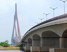
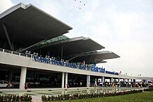
Cần Thơ is connected to the rest of the country by National Road 1A and Cần Thơ International Airport. The city's bridge which is now completed, is the longest cable-stayed bridge in South East Asia. The 6-lane Saigon–Cần Thơ Exressway is being built in parts from Hồ Chí Minh City to Mỹ Tho. The hydrofoil express boat links this city with Saigon.
Tourism


The Mekong Delta is considered to be the “rice basket of Vietnam,” contributing more than 50% of the nation’s rice production. People say of Cần Thơ:
Cần Thơ gạo trắng nước trong, Ai đi đến đó lòng không muốn về.
Cần Thơ, white rice, pure water, All who come wish never to leave.
Cần Thơ City is famous for its floating markets, where people sell and buy things on the river, as well as the bird gardens and the port of Ninh Kiều. The city offers a wide range of tropical fruits such as pomelo, longan, jackfruit, mango and durian.
Education
Academic institutions in the city are Cần Thơ University, Cần Thơ University of Medicine and Pharmacy, Tây Đô University, Cần Thơ College, College of Foreign Economic Relations - Cần Thơ Branch, Medical College, The Economic and Technical College and Vocational College, with its well-known College of Agriculture and Mekong Delta Rice Research Institute.
Economy


After 120 years of development, the city now is the delta's most important centre of economics, culture, science and technology. It has a large freshwater port and two industrial parks.
Landmarks


References
External links
| Places adjacent to Cần Thơ | ||||||||||||||||
|---|---|---|---|---|---|---|---|---|---|---|---|---|---|---|---|---|
| ||||||||||||||||
| Districts of the Mekong Delta | ||
|---|---|---|
| Cần Thơ city |  | |
| An Giang province | ||
| Bạc Liêu province | ||
| Bến Tre province | ||
| Cà Mau province | ||
| Đồng Tháp province | ||
| Hậu Giang province |
| |
| Kiên Giang province | ||
| Long An province | ||
| Sóc Trăng province | ||
| Tiền Giang province |
| |
| Trà Vinh province | ||
| Vĩnh Long province | ||
| denotes provincial seat. | ||
10°02′N 105°47′E / 10.033°N 105.783°E / 10.033; 105.783
Categories: