This is an old revision of this page, as edited by Nurg (talk | contribs) at 09:34, 26 December 2012 (rm Category:Lakes of New Zealand; leave Category:Lakes of the Otago Region). The present address (URL) is a permanent link to this revision, which may differ significantly from the current revision.
Revision as of 09:34, 26 December 2012 by Nurg (talk | contribs) (rm Category:Lakes of New Zealand; leave Category:Lakes of the Otago Region)(diff) ← Previous revision | Latest revision (diff) | Newer revision → (diff)| Lake Waihola | |
|---|---|
| Location | Clutha District, Otago Region, South Island |
| Coordinates | 46°01′S 170°06′E / 46.017°S 170.100°E / -46.017; 170.100 |
| Primary outflows | Waipori River |
| Basin countries | New Zealand |
| Surface area | 9 km² |

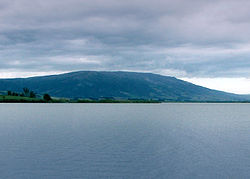
Lake Waihola is a tidal freshwater lake located 15 km north of Milton in Otago, in New Zealand's South Island. Its area is some 9 square kilometres, with a maximum length of 6 kilometres.
It is the larger of a pair of existing lakes - the other being Lake Waipori - which lie in a small area of low hills between the Taieri and Tokomairiro. Waihola is drained by the Waipori River, a tributary of the Taieri. Both lakes are very shallow and surrounded by wetlands, including the internationally renowned and protected Sinclair Wetlands which are the home to many species of wading birds. This shallowness is reflected in the name Waihola, the southern Maori form of the word waihora, which means "spreading waters".
Lake Waihola is a popular day trip for holidaymakers from Dunedin, 40 km to the north. The small township of Waihola (population 200), nestled against the lake's eastern edge, has facilities for fishing, yachting, and waterskiing, and the lake is an important rowing venue.
History
Lake Waihola was used in the Central Otago goldrush. Ships used to travel up the Taieri River and across to the southern side of the lake where prospectors would traverse the hills and on to Gabriel's Gully. In the early days of settlement a paddle-steamer, the Betsy Douglas, plied the lake's waters from Owhiro, near Henley in the north to Clarendon at the lake's southern end.
Lake Waihola is located at the southern end of the lower Taieri Plains and is the largest of a group of historical lakes that were once distributed between Lake Waihola and Mosgiel. Other neighbouring historical lakes include Lake Tatawai, Loch Ascog, Loch Katrine, Lake Potaka and Silverstream Lagoon
Curious Facts
Lake Waihola has attracted international interest due to the ecosystems based in a shallow freshwater tidal system. Since 2000, Danish scientists have been conducting annual studies of the lake. Waihola is reputedly the home to a species of otter, the cryptid waitoreke, but no verified sightings have ever confirmed the animal's existence.
Notes
- Bray, Sharon. "Under the Eye of the Saddle Hill Taniwha", 1998.
- New Zealand Ecological Society report (PDF format).
| Taieri River | |
|---|---|
| Source: Lammerlaw Range. Flows into: Pacific Ocean | |
| Administrative areas | |
| Towns and settlements (upstream to downstream) | |
| Tributaries (upstream to downstream by confluence) | |
| Lakes in catchment (upstream to downstream by location or tributary) |
|
| Islands in catchment (upstream to downstream by location or tributary) | |
| Other features (upstream to downstream) | |