This is an old revision of this page, as edited by Branddobbe (talk | contribs) at 04:24, 29 June 2004 (+nds). The present address (URL) is a permanent link to this revision, which may differ significantly from the current revision.
Revision as of 04:24, 29 June 2004 by Branddobbe (talk | contribs) (+nds)(diff) ← Previous revision | Latest revision (diff) | Newer revision → (diff)| Flag | |
|---|---|
 | |
| Statistics | |
| Capital: | Saarbrücken |
| Area: | 2570 km² |
| Inhabitants: | 1,080,000 (2000) |
| pop. density: | 420 people/km² |
| Homepage: | http://www.saarland.de/ |
| ISO 3166-2: | DE-SL |
| Politics | |
| Minister-President: | Peter Müller (CDU) |
| Ruling party: | CDU |
| Map | |
| File:Bundeslaender germany sl.png | |
With an area of 2570 km² and 1.08 million inhabitants, Saarland is one of the 16 Bundesländer (federal states) in Germany. The capital is Saarbrücken.
Geography
The state borders France in the south, Luxembourg in the west and Rhineland-Palatinate in the north and the east.
It is named after the Saar River, which is an affluent of the Moselle River and runs through the state from the south to the northwest. Most inhabitants live in a city agglomeration on the French border, surrounding the capital of Saarbrücken.
See also List of places in Saarland.
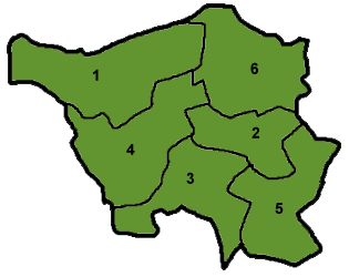
Saarland is divided into six districts:
History
The territory was established in 1920 in accordance with the Treaty of Versailles. It comprised portions of the Prussian Rhine Province and the Rhine Palatinate. The area was put under the control of the League of Nations for 15 years. After this period a plebiscite was held on January 13, 1935: 90.3% of those voting wished to join Germany . The Nazis called the area "Westmark".
After World War II the Saarland came under French administration. France and Germany decided in 1954 to establish an independent Saarland, but these plans were refused in a plebiscite. In new French-German consultations there was an agreement, that Saarland should be allowed to rejoin Germany (Saar Treaty, October 27, 1956). On January 1, 1957, Saarland became a part of Germany again.
The Saar competed in football's 1954 FIFA World Cup qualifying, failling after coming second to West Germany but ahead of Norway.
From 1920 to 1935, and then from 1947 to 1959, the inhabitants used postage stamps issued specially for the territory; see postage stamps and postal history of the Saar for details.
List of Minister-Presidents of the Saarland
(or equivalent position)
- 1945 - 1946: Hans Neureuther
- 1946 - 1947: Erwin Müller
- 1947 - 1955: Johannes Hoffmann
- 1955 - 1956: Heinrich Welsch
- 1956 - 1957: Hubert Ney
- 1957 - 1959: Egon Reinert
- 1959 - 1979: Franz Josef Röder
- 1979: Werner Klumpp
- 1979 - 1985: Werner Zeyer
- 1985 - 1998: Oskar Lafontaine (SPD)
- 1998 - 1999: Reinhard Klimmt (SPD)
- since 1999: Peter Müller (CDU)
External links
| States of the Federal Republic of Germany | ||
|---|---|---|
| States |
|  |
| City-states | ||
| Former states |
| |
