This is an old revision of this page, as edited by 38.112.107.82 (talk) at 14:53, 15 March 2013 (→Former mayors). The present address (URL) is a permanent link to this revision, which may differ significantly from the current revision.
Revision as of 14:53, 15 March 2013 by 38.112.107.82 (talk) (→Former mayors)(diff) ← Previous revision | Latest revision (diff) | Newer revision → (diff) Community in Ontario, Canada| Capreol | |
|---|---|
| Community | |
 | |
 Location of Capreol within Greater Sudbury. Location of Capreol within Greater Sudbury. | |
| Country | |
| Province | |
| City | Greater Sudbury |
| Ward | 7 |
| Incorporated | 1918 |
| Government | |
| • City Councillor | Dave Kilgour |
| • Governing Body | Greater Sudbury City Council |
| • MP | Claude Gravelle (NDP) |
| • MPP | France Gélinas (NDP) |
| Population | |
| • Total | 3,817 |
| Time zone | UTC−5 (EST) |
| • Summer (DST) | UTC−4 (EDT) |
| Postal Code FSA | P0M 1H0 |
| Area code | 705 |
| Website | Capreol Community Action Network |
Capreol is a community in the Ontario city of Greater Sudbury.
From 1918 to 2000, Capreol existed as an independent town, situated on the Vermilion River. On January 1, 2001, the towns and cities of the Regional Municipality were amalgamated into the single-tier city of Greater Sudbury.
In 1996, the last Canadian census before the municipal amalgamation, Capreol had a population of 3,817. In the Canada 2011 Census, Capreol was listed for the first time as one of six distinct population centres (or urban areas) within the city, with a population of 3,276 and a population density of 537.7 km; however, the boundaries of this statistical aggregation correspond only to the main townsite of Capreol, and not to the full municipal boundaries as they existed prior to 2001.
History
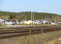
Capreol formed around the Capreol railway station, which was a major divisional point on the Canadian National Railway line, and was named for Frederick Chase Capreol, the original promoter of the Northern Railway of Canada. The first family to move into Capreol was Adolph and Margaret Sawyer, both of whom pioneered in farming.
Although the town was originally an independent community with its own thriving economy, it gradually became a satellite community to the more rapidly growing city of Sudbury, approximately 40 kilometres to the south. In 1916, there were thirty families in town, and by 1919, sixty houses had been built. It was then decided that Capreol would build its own YMCA. In 1920, the construction of the YMCA was in progress, but was damaged by fire, to the extent of $40,000.00. The YMCA was rebuilt at double the cost and finally opened in 1921.
In 1973, the boundaries of the town of Capreol were expanded to include the nearby villages of Sellwood and Milnet, and the town was incorporated into the Regional Municipality of Sudbury. However, despite its status as part of the Regional Municipality, during this era Statistics Canada did not include the town in Sudbury's Census Metropolitan Area.
The town is part of Ward 7 on Greater Sudbury City Council, and is represented by councillor Dave Kilgour. In recent years, Capreol citizens have voiced their concerns that the city government does not adequately serve the community's needs. For example, they cite lack of a police presence and increasing vandalism as areas that Sudbury needs to improve on.
Sports and culture
Capreol is the location of the Northern Ontario Railroad Museum.
From 1978 to 1986, Capreol had a Northern Ontario Junior Hockey League team called the Capreol Hawks, who won the league title in 1980-81.
Ghost towns
The former villages of Milnet and Sellwood, located within the area annexed by Capreol in 1973, are both now ghost towns.
Milnet (originally named Sellwood Junction up to 1916) began as a stop along the Canadian Northern Railway. In 1917, after the railway was laid down, the Marshay Lumber Company built a mill and began a 22-year process of cutting trees from the area. Men from logging camps upstream would let the Vermilion River carry the logs to the mill in Milnet. From there the men at the mill would cut the wood on the blade and then move it along to the planar mill.
An open pit mine now stands where the Sellwood townsite once was.
Former mayors
incomplete list
- James E. Coyne
- Harold Prescott
- Norman Fawcett
- Frank Mazzuca
- Dave Kilgour
- Julian T. Howe
- Alistair MacLean
- John MacLean
Images
References
- Canada 1996 Census Community Profiles: Capreol.
- Canada 2011 Census Community Profiles: Population Centre of Capreol. Statistics Canada.
External links
- Capreol Online
- Capreol's Information Pages
- Ontario Abandoned Places: Milnet
- History of Capreol at Greater Sudbury Heritage Museums
46°42′N 80°55′W / 46.700°N 80.917°W / 46.700; -80.917
Categories:
