This is an old revision of this page, as edited by WeggeBot (talk | contribs) at 01:42, 8 June 2006 (robot Modifying: sv:Dnepr). The present address (URL) is a permanent link to this revision, which may differ significantly from the current revision.
Revision as of 01:42, 8 June 2006 by WeggeBot (talk | contribs) (robot Modifying: sv:Dnepr)(diff) ← Previous revision | Latest revision (diff) | Newer revision → (diff) For other uses of "Dnieper", see Dnieper (disambiguation). River| Dnieper | |
|---|---|
 | |
| Physical characteristics | |
| Mouth | Black Sea |
| Length | 2,290 km (1,423 mi) |
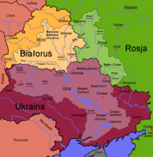
The Dnieper River (also: Dnepr, Dniapro, or Dnipro) is a river (2,290 km length) which flows from Russia through Belarus and then Ukraine.
In all three countries it has essentially the same name, albeit pronounced differently, Template:Lang-ru; Template:Lang-be; Template:Lang-uk. The river is mentioned by the Ancient Greek historian Herodotus in the fifth century BC as Borysthenes; the late Greek and Roman authors called it Danapris and Danaper respectively. Its Old Slavic name used at times of Kievan Rus' was Slavutich "the Slavic (river)".
The Dnieper finds its source in the Valday Hills of central Russia, and runs south eventually flowing into the Black Sea. 115 kilometres of its length serves as a natural border between Belarus and Ukraine. Approximately the last 800 kilometres of the river is a chain of nearly consecutive reservoirs.
These reservoirs are: Kiev (922 km²), Kaniv (582 km²), Kremenchuk (2,252 km²), Dniprodzerzhynsk (567 km²), Zaporizhzhia (410 km²), and Kakhovka (2,155 km²). The dams forming these are used to generate hydroelectric power, providing around ten percent of Ukraine's electricity.
The Dnieper is connected with the Western Bug by the Dnieper-Bug Canal. Its estuary, or liman, used to be defended by the strong fortress of Ochakov.
Navigation
The Dnieper river is important for the transport and economy of Ukraine: the river's reservoirs have all been equipped with large ship locks, allowing vessels of up to 270×18 metres to access even the port of Kiev and thus creating a perfect transport corridor. The river is used by passenger vessels too: inland cruises on the rivers Danube and Dnieper have been a growing market in recent decades.
Upstream from Kiev the Dnieper receives the water of the Pripyat river. This navigable river connects to the Dnieper-Bug canal, the link with the Polish river Bug. Historically a connection with the Western European waterways was possible, but a weir without a ship lock near the town of Brest has interrupted this interesting international waterway. The political relation between Western Europe and Belarus does not allow for much hope of reopening of this direct inland shipping link any time soon. NoorderSoft Waterways Database
Hydroelectric power
The river is very famous for its dams, which were often touted as achievements of Soviet Industry. The most famous one was the Dnieper Hydroelectric Station or (DneproGES) near Zaporizhia, which was built in 1927-1932 with an output of 558 MW. The Second World War completely destroyed the station and in 1948 it was rebuilt (using concentration camp labour-GULAG) and its capacity output increased to 750 MW.
The Kremenchuk Hydroelectric Station was the second one built in 1954–60, the Kiev Hydroelectric Station followed 1960–64, the Dneprodzerzhinsk Hydroelectric Station in 1956–64, and the Kanev Hydroelectric Station 1963–75 completed the Cascade of Dams.
Cities and towns on the Dnieper
From the source to the mouth.
- Dorogobuzh, Russia
- Smolensk, Russia
- Orsha, Belarus
- Škloŭ, Belarus
- Mogilev, Belarus
- Bychaŭ, Belarus
- Rahačoŭ, Belarus

Dnieper River in Dorogobuzh, before 1917. - Žłobin, Belarus
- Rečyca, Belarus
- Kiev (Kyiv), Ukraine
- Kaniv, Ukraine
- Cherkasy, Ukraine
- Kremenchuk, Ukraine
- Dniprodzerzhyns'k, Ukraine
- Dnipropetrovs'k, Ukraine
- Zaporizhzhia, Ukraine
- Marhanets', Ukraine
- Nikopol', Ukraine
- Nova Kakhovka, Ukraine
- Kherson, Ukraine
Arheimar, a capital of the Goths, was located on the Dniepr, according to the Hervarar saga.
Tributaries of the Dnieper


In orographic sequence.
- Druć (R)
- Berezina (R)
- Sozh (L)
- Prypiat (R)
- Teteriv (R)
- Irpin (R)
- Desna (L)
- Stuhna (R)
- Trubizh (L)
- Ros (R)
- Tiasmyn (R)
- Supiy (L)
- Sula (L)
- Pslo (L)
- Vorskla (L)
- Samara (L)
- Konka (L)
- Bilozerka (L)
- Bazavluk (R)
- Inhulets (R)
See also
External links
- Dnieper River at the Encyclopedia of Ukraine