This is an old revision of this page, as edited by Ganeshbot (talk | contribs) at 07:34, 30 October 2006 (replace with Infobox Indian Jurisdiction box). The present address (URL) is a permanent link to this revision, which may differ significantly from the current revision.
Revision as of 07:34, 30 October 2006 by Ganeshbot (talk | contribs) (replace with Infobox Indian Jurisdiction box)(diff) ← Previous revision | Latest revision (diff) | Newer revision → (diff)- For other uses, see Aurangabad
| Aurangabad district, Maharashtra Aurangabad | |
|---|---|
 | |
| Population | |
| • Total | 2,897,013 |
| Area code | 0240 |
| Website | aurangabad.nic.in |
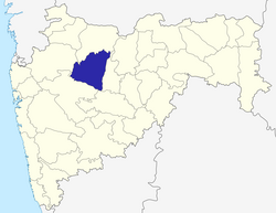
Aurangabad District is a District in Maharashtra, India. It is bordered by the districts of Nashik to the west, Jalgaon to the north, Jalna to the east, and Ahmednagar to the south. Aurangabad is the capital and principal city. The district is 37.53% urban as of 2001.

- Area: 10,106 km²
- Population: 2,897,013 (2001)
- Population density: 289/km² (2001)
- Literacy: 62.8% (2001)
- Urbanization: 37.53% (2001)
Aurangabad District is divided into 8 Talukas named Soygaon, * Sillod, Kannad, Phulambri, Khultabad, Paithan, Vaijapur and Gangapur.
Also see
| Topics | |||||||||||||
|---|---|---|---|---|---|---|---|---|---|---|---|---|---|
| Regions | |||||||||||||
| Divisions and Districts |
| ||||||||||||
| Million-plus cities in Maharashtra | |||||||||||||
| Other cities with municipal corporations | |||||||||||||
| Government | |||||||||||||
| Portal:India | |||||||||||||
This article about a location in the Indian state of Maharashtra is a stub. You can help Misplaced Pages by expanding it. |