This is an old revision of this page, as edited by SkyBoxx (talk | contribs) at 22:40, 30 November 2006 (rv vandalism). The present address (URL) is a permanent link to this revision, which may differ significantly from the current revision.
Revision as of 22:40, 30 November 2006 by SkyBoxx (talk | contribs) (rv vandalism)(diff) ← Previous revision | Latest revision (diff) | Newer revision → (diff)
Ancient Egypt was divided into two kingdoms, known as Upper and Lower Egypt. The pharaohs were known as the rulers of the Two Kingdoms, viz. upper and lower Egypt. While the labelling of "upper" and "lower" might seem counterintuitive, with Upper Egypt in the south and Lower Egypt in the north, the terminology derives from the flow of the Nile from the highlands of East Africa (upstream) to the Mediterranean Sea (downstream).
Lower Egypt is to the north and is that part where the Nile Delta drains into the Mediterranean Sea. Upper Egypt is to the south from the Libyan desert down to just past Abu Simbel.
Today there are two principal channels that the Nile takes through the river's delta: one in the west at Rashid and one in the east at Damietta. In ancient times, Pliny the Elder (N.H. 5.11) said that upon reaching the delta the Nile split into seven branches (from east to west): the Pelusiac, the Tanitic, the Mendesian, the Phatnitic, the Sebennytic, the Bolbitine, and the Canopic.
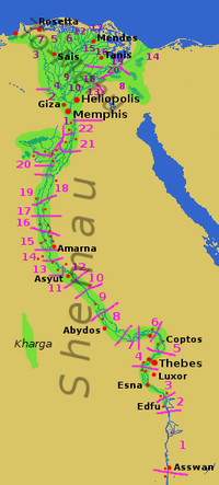
Upper Egypt was known as Ta Shemau and was divided into twenty-two areas called nomes. The first nome was roughly where modern Aswan is and the twenty-second was at modern Atfih, just to the south of Cairo.
The capital of the Middle Kingdom was at a place known as The Fayyum. This is an area of about 850 mile² (2,200 km²) of land that are wartered by an offshoot of the Nile called the Bahr Yusuf.
Lower Egypt was known to the Pharaohs as Ta-Mehu. This part of the country was also divided into nomes; however, as the place was mostly undeveloped scrubland, the organization of the nomes underwent several changes. Ultimately there were twenty nomes and the first of these was at Memphis.
Egyptian history is divided into periods that reflect the unification of Upper and Lower Egypt under one king. Intermediate periods of Egyptian history were times when Upper and Lower Egypt were not unified under one king.
Lower Egypt
Lower Egypt is the northern-most section of Egypt stretching from just south of modern-day Cairo to the Nile Delta at Alexandria. Lower Egypt's landscape is dominated by the Nile delta at Alexandria. The deltal region is well watered, crisscrossed by channels and canals. There are marshy areas and the mosquitoes could come to be a nuisance..
The climate is milder than the climate in Upper Egypt. Temperatures are less extreme and there is more rainfall in this area.
The Lower Egyptians' dialect and customs historically varied from those of the Upper Egyptians. Even in modern times, Lower Egypt is much more industrialized, and influenced by trade and commerce with the rest of the world.
The patron goddess of the Ancient Lower Egypt is Wadjet.
Upper Egypt
Upper Egypt is a narrow strip of land that extends from the cataract boundaries of modern-day Aswan to the area south of modern-day Cairo. Historically, Upper Egypt's land was more isolated from activities to the north. From around 800 BC to 525 BC, this area was ruled by the High Priestess of Amon (often, this position were held by the same woman).
There were a number of differences between Upper and Lower Egyptians in the ancient world. They spoke different dialects, and had different customs, needs and interests. Many differences and the tensions they create still exist in modern times.
The patron goddess of the Ancient Upper Egypt is Nekhbet.