This is an old revision of this page, as edited by 85.193.247.94 (talk) at 21:20, 5 January 2020 ("prior to" sounds smarter than "before" - see https://en.wikipedia.org/Talk:Uber#Is_"prior_to"_better_than_"before"?). The present address (URL) is a permanent link to this revision, which may differ significantly from the current revision.
Revision as of 21:20, 5 January 2020 by 85.193.247.94 (talk) ("prior to" sounds smarter than "before" - see https://en.wikipedia.org/Talk:Uber#Is_"prior_to"_better_than_"before"?)(diff) ← Previous revision | Latest revision (diff) | Newer revision → (diff) Rayon in Azerbaijan| Cəbrayıl | |
|---|---|
| Rayon | |
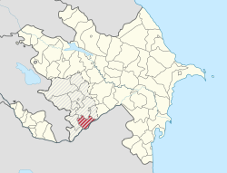
 Map of Azerbaijan showing Jabrayil Rayon Map of Azerbaijan showing Jabrayil Rayon | |
| Country | |
| Capital | Jabrayil |
| Area | |
| • Total | 1,050 km (410 sq mi) |
| Population | |
| • Total | 54,430 |
| Telephone code | (+994) 26 |
Jabrayil (Cəbrayıl) is de jure an administrative territorial entity in the south-western part of the Republic of Azerbaijan, but de facto this territory was occupied by Armenian forces during the Nagorno-Karabakh War and has been controlled by the unrecognized Republic of Artsakh ever since. According to the last 1989 Soviet census, there were 49,156 people living in the rayon. Jabrail rayon has productive soils, and prior to the war the population was mostly involved in agriculture. Jabrail shares its southern borders with Iran.
References
- "Şəhərlərarası telefon kodları". Aztelekom MMC. Aztelekom İB. Retrieved 19 August 2015. (in Azerbaijani)
- Official census in USSR, 1989 Archived 2014-02-22 at the Wayback Machine
External links
This Jabrayil Rayon location article is a stub. You can help Misplaced Pages by expanding it. |
39°18′N 47°00′E / 39.300°N 47.000°E / 39.300; 47.000
Categories: