This is an old revision of this page, as edited by Akul59 (talk | contribs) at 06:52, 10 April 2020 (links, commons). The present address (URL) is a permanent link to this revision, which may differ significantly from the current revision.
Revision as of 06:52, 10 April 2020 by Akul59 (talk | contribs) (links, commons)(diff) ← Previous revision | Latest revision (diff) | Newer revision → (diff) Municipality in Slovakia| Málinec | |
|---|---|
| Municipality | |
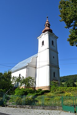
 Lutheran church Lutheran church | |
  | |
| Coordinates: 48°30′N 19°41′E / 48.500°N 19.683°E / 48.500; 19.683 | |
| Country | |
| Region | Banská Bystrica |
| District | Poltár |
| First mentioned | 1514 |
| Area | |
| • Total | 49.960 km (19.290 sq mi) |
| Elevation | 527 m (1,729 ft) |
| Population | |
| • Total | 1,518 |
| • Density | 30/km (79/sq mi) |
| Postal code | 985 26 |
| Area code | +421-47 |
| Car plate | PT |
| Website | malinec.sk |
Málinec is a village and municipality in the Poltár District in the Banská Bystrica Region of Slovakia. It is located 13 km north of the district center. In the near o Málinec is water reservoir, which supplies several locations in Poltár District. The village is a starting point of the cycling event Novohradský cyklomaratón.
External links
 Media related to Málinec at Wikimedia Commons
- Official website

- Málinec information e-obce.sk
- Málinec news sme.sk
- Homepage of cycling event
| Municipalities of Poltár District | ||
|---|---|---|
This Banská Bystrica Region geography article is a stub. You can help Misplaced Pages by expanding it. |