This is an old revision of this page, as edited by Nilfanion (talk | contribs) at 22:49, 19 December 2006 (subst'ing {{tcseason}} using AWB). The present address (URL) is a permanent link to this revision, which may differ significantly from the current revision.
Revision as of 22:49, 19 December 2006 by Nilfanion (talk | contribs) (subst'ing {{tcseason}} using AWB)(diff) ← Previous revision | Latest revision (diff) | Newer revision → (diff) This article is about the Atlantic hurricane of 2003. For other storms of the same name, see Tropical Storm Juan.| hurricane | |
|---|---|
| Formed | September 24, 2003 |
| Dissipated | September 29, 2003 |
Hurricane Juan was the tenth named storm and the sixth hurricane of the 2003 Atlantic hurricane season. It was a Category 2 hurricane that struck the Canadian provinces of Nova Scotia and Prince Edward Island, causing significant damage to trees and property, particularly within the urban core of the Halifax Regional Municipality on September 29, 2003. The storm killed 8 and caused over $200 million in damages (2003 USD, $220 million 2006 USD). It was the region's most powerful hurricane since 1893.
Storm history

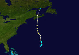
Map key Saffir–Simpson scale Tropical depression (≤38 mph, ≤62 km/h)
Tropical storm (39–73 mph, 63–118 km/h)
Category 1 (74–95 mph, 119–153 km/h)
Category 2 (96–110 mph, 154–177 km/h)
Category 3 (111–129 mph, 178–208 km/h)
Category 4 (130–156 mph, 209–251 km/h)
Category 5 (≥157 mph, ≥252 km/h)
Unknown Storm type
 Tropical cyclone
  Subtropical cyclone
  Extratropical cyclone, remnant low, tropical disturbance, or monsoon depression
 A large tropical wave accompanied by a broad area of low pressure moved off the coast of Africa on September 14. It moved westward, and due to unfavorable upper level wind shear the system remained disorganized. On September 20, while the wave was located about 690 miles (1100 km) east of the Lesser Antilles, convection around the system greatly increased while interacting with the circulation of a large upper-level low, though unfavorable conditions caused it to remain disorganized. The system as a whole moved to the northwest around the upper-level low and developed a mid-level circulation. It interacted with a frontal zone, and became better organized on September 23 while located 450 miles (725 km) south of Bermuda. Later that day, a low-level circulation developed within the system, though its involvement with a nearby frontal zone prevented it being classified a tropical depression. Deep convection increased near the center on September 24, and it quickly organized to develop banding features and a distinct outflow. Based on its organization, it is estimated the system developed into Tropical Depression Fifteen later on September 24 while located about 345 miles (555 km) southeast of Bermuda. Operationally, the National Hurricane Center did not begin issuing advisories until 27 hours after it actually formed.
Initially, the depression possessed tropical and subtropical characteristics; it maintained attachment to a nearby frontal zone, though the organization of the convection and a warm core within the system resulted in classification as a tropical cyclone. Forecasters predicted the depression would only slowly strengthen and reach a peak intensity of 65 mph. However, the depression steadily organized and strengthened into Tropical Storm Juan early on September 25. Later that day, the center of circulation became embedded within the convection. Juan moved northwestward at around 10 mph, a motion due to the presense of a developing subtropical ridge to its east. On September 26, an eye featured developed, and very deep convection developed near the circulation. The cloud pattern continued to organize, and Juan attained hurricane status later on the 26th while located 165 miles (270 km) southeast of Bermuda. As the hurricane moved into an area of warm waters and light wind shear, it strengthened and organized further, and on September 27, Juan attained a peak intensity of 105 mph (170 km/h) while located 635 miles (1020 km) south of Halifax, Nova Scotia. At its peak strength, the eye of the hurricane was distinct and embedded within a well-defined and round central dense overcast.

Hurricane Juan remained at peak intensity for over 24 hours. After moving northwestward for an extended period of time, it turned and accellerated to the north. On September 28, the eye became less distinct, and the hurricane weakened slightly. Due to its fast forward motion, it had little time to weaken over significant colder waters, and Juan made landfall near Halifax, Nova Scotia on September 29 with winds of 100 mph (160 km/h). It weakened quickly while moving over the Canadian Maritimes, quickly crossing Nova Scotia as a hurricane, downgrading to a tropical storm as it crossed over Prince Edward Island early that morning. Later that day, Tropical Storm Juan was absorbed by a large extratropical storm in the northwestern Gulf of Saint Lawrence.
Preparations
On September 27, as Juan approached, warning broadcasts on local media in Atlantic Canada were changed accordingly and the public and emergency officials in the expected landfall area were told to make preparations for a potential disaster.
On Sunday morning, September 28th the latest reports indicated that Juan would make landfall either as a tropical storm or marginal category one hurricane. Weather broadcasts up to that time gave every indication that the storm would weaken prior to landfall. By 6 p.m., additional warnings were issued, as Juan was expected to make landfall as a strong Category 1 or weak Category 2 hurricane. At this point it was too late for much of the general public to make necessary preparations.
Impact

Juan caused widespread damage in central Nova Scotia and Prince Edward Island. Hurricane Juan's maximum sustained wind speed at landfall in Nova Scotia was measured at 100 mph (160 km/h). The majority of severe property damage was concentrated in the western urban core of the Halifax Regional Municipality. Less severe property damage was recorded west of the storm's track into St. Margaret's Bay and Mahone Bay. In addition to Halifax Regional Municipality's urban core, the town of Truro and city of Charlottetown were urban areas which also experienced significant property damage.
The urban concentration surrounding Halifax Harbour bore the brunt of the highest sustained winds and strongest wind gusts during the storm; some unofficial estimates have placed gusts as high as 145 mph (230 km/h). Wave-rider weather buoys off the entrance of Halifax Harbour snapped their moorings after reportedly recording waves in excess of 20 metres (65 ft). Significant erosion occurred on the populated shores of the harbour, particularly in the Bedford Basin where residential properties and railway tracks got most of the wave action. The severity of property damage in the urban core of Halifax Regional Municipality initially led some forecasters to believe that Juan was likely a Category 3 hurricane, however the sustained wind reports did not justify that suggestion. Many of the deciduous trees in central Nova Scotia still had leaves, which magnified the effects of wind damage.
Juan left more than 800,000 people without power in both Nova Scotia and Prince Edward Island. It took up two weeks to restore power to the hardest hit rural areas of Nova Scotia's Eastern Shore and the Musquodoboit River valley. Voting in the PEI general election on September 29, 2003 was also disrupted but more than 80% of voters made it to polling stations.
70% of the trees in Halifax's Point Pleasant Park were destroyed, fundamentally changing the character of the large urban park. The Halifax Public Gardens was also badly damaged. Charlottetown's waterfront sustained heavy wave damage to pleasure craft and sea walls, as well as significant damage to the older urban forest in that city's downtown core.
Juan claimed 4 lives directly and 4 indirectly in Nova Scotia and Quebec, although those lost in the latter province were actually fishermen from New Brunswick operating near Anticosti Island.
Aftermath


Hurricane Juan alerted residents, governments, utilities, and emergency management agencies throughout Atlantic Canada to improve preparations for devastating events such as hurricanes, especially with climatological data pointing to possible increased frequency of major ocean storms and extratropical cyclones. In addition to Juan, three other storms—Fabian, Isabel and Kate—had a significant effect on land or offshore in Canada.
Preparations and planning have been underway since 2003 and were tested most recently when Hurricane Ophelia was forecast to brush near Nova Scotia in early September 2005. Hurricane Juan has also resulted in several changes to the Meteorological Service of Canada's Canadian Hurricane Centre, which has relocated from a vulnerable and exposed office building in Dartmouth, Nova Scotia to a more secure location that can withstand hurricane damage. CHC's hurricane warning system has also been improved; traditionally, CHC did not issue standard hurricane or tropical storm watches or warnings (just high wind and heavy rainfall warnings), which were not heeded by local residents. Beginning in the 2004 Atlantic hurricane season, CHC began using standard hurricane warnings for storms potentially affecting Canada.
Retirement
See also: List of retired Atlantic hurricanesBecause of its effects in Canada, the name Juan was retired in April 2004 and will never again be used for an Atlantic hurricane. It was the first time that the Meteorological Service of Canada had specifically requested a hurricane name be retired; most hurricanes which have affected Canada in the past had previously caused damage elsewhere, usually along the US East Coast. The name was replaced by Joaquin for the 2009 season.
References
- ^ Chris Fogarty (2003). "Hurricane Juan Storm Summary" (PDF). Canadian Hurricane Centre/Environment Canada. Retrieved 2006-11-20.
- ^ Lixion A. Avila (2003). "Hurricane Juan Tropical Cyclone Report". National Hurricane Center. Retrieved 2006-10-30.
- Avila (2003). "September 17 Tropical Weather Outlook". NHC. Retrieved 2006-10-30.
- Avila (2003). "September 23 Tropical Weather Outlook". Retrieved 2006-10-30.
- Avila (2003). "Tropical Depression Fifteen Discussion Fifteen". NHC. Retrieved 2006-10-30.
- Avila (2003). "Tropical Storm Juan Discussion Two". NHC. Retrieved 2006-10-30.
- Stewart (2003). "Tropical Storm Juan Discussion Four". NHC. Retrieved 2006-10-30.
- Avila (2003). "Hurricane Juan Discussion Ten". NHC. Retrieved 2006-10-30.
- Pasch (2003). "Hurricane Juan Discussion Fourteen". NHC. Retrieved 2006-10-30.
- Parkes (2003). "Canadian Hurricane Centre Information Statement, 0600 UTC September 28". Environment Canada. Retrieved 2006-11-20.
- Parkes (2003). "Canadian Hurricane Centre Information Statement, 1800 UTC September 28". Environment Canada. Retrieved 2006-11-20.
- Peter Boywer (2003). "Classifying Hurricane Juan". Environment Canada. Retrieved 2006-11-20.
- ^ Peter Boywer (2003). "The Storm Surge and Waves at Halifax with Hurricane Juan". Environment Canada. Retrieved 2006-11-20. Cite error: The named reference "surge" was defined multiple times with different content (see the help page).
- Murray Brewster (2004). "Why Did Juan Hit So Hard?" (PDF). Halifax Herald. Retrieved 2006-11-20.
- "2003 Atlantic Season Hammers Atlantic Coast". Environment Canada. 2003. Retrieved 2006-11-20.
- "Atlantic Season 2004 Preview". Environment Canada. 2004. Retrieved 2006-11-20.
- John Parker (2004). "Working Together to Understand the Risks" (PDF). Meteorological Service of Canada. Retrieved 2006-11-20.
See also
- List of notable tropical cyclones
- List of notable Atlantic hurricanes
- List of retired Atlantic hurricanes
External links
- National Hurricane Center Tropical Cyclone Report – Hurricane Juan
- Environment Canada's Juan Information Page
- CTV Hurricane Juan retrospective story
- The Hurricane Hut – Comprehensive Summary of Hurricane Juan
- Novaweather Storm Page – Chris Fogarty's study of the storm
| Tropical cyclones of the 2003 Atlantic hurricane season | ||
|---|---|---|
 | TSAna TDTwo TSBill 1Claudette 1Danny TDSix TDSeven 1Erika TDNine 4Fabian TSGrace TSHenri 5Isabel TDFourteen 2Juan 3Kate TSLarry TSMindy TSNicholas TSOdette TSPeter | |