This is an old revision of this page, as edited by Arminden (talk | contribs) at 16:46, 18 June 2020 (→Name). The present address (URL) is a permanent link to this revision, which may differ significantly from the current revision.
Revision as of 16:46, 18 June 2020 by Arminden (talk | contribs) (→Name)(diff) ← Previous revision | Latest revision (diff) | Newer revision → (diff)| Dung Gate | |
|---|---|
 Dung Gate Dung Gate | |
 | |
| General information | |
| Town or city | Jerusalem |
| Coordinates | 31°46′29″N 35°14′2″E / 31.77472°N 35.23389°E / 31.77472; 35.23389 |
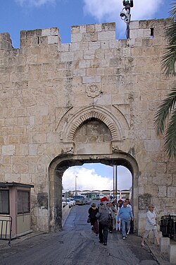
The Dung Gate (Template:Lang-he Sha'ar Ha'ashpot) or Mughrabi Gate (Template:Lang-ar Bab al-Maghariba), or Silwan Gate (since medieval times) is one of the Gates of the Old City of Jerusalem. It was built as a small postern gate in the 16th century by the Ottomans, first widened for vehicular traffic in 1952 by the Jordanian, and again in 1985 by the Israeli authorities.
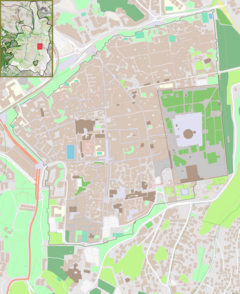
The gate is situated near the southeast corner of the Old City, southwest of the Temple Mount.
Directly behind the gate lies the entrance to the Western Wall Plaza. The Dung Gate is a main passage for vehicles coming out of the Old City and for buses headed to the Western Wall.
Name
The name Sha'ar Ha'ashpot appears in the Book of Nehemiah (Neh 3:13–14)Template:Bibleverse with invalid book. It is probably named after the residue that was taken from the Jewish Temple into the Valley of Hinnom, where it was burned. This ancient "Dung Gate" may not have been in the same location as the 16th-century gate, which only received this name in the 19th century.
Although Dung Gate is also known as the Mughrabi Gate, that name normally refers to one of the gates of the Temple Mount, which is inside the Old City walls. The name alludes to the Mughrabi Quarter, a neighborhood of North African Kutama Fatimids which was situated between both gates until 1967.
The name Silwan Gate refers to the village of Silwan that lies outside the gate, broadly southeast of it.
History
The Dung Gate was built as part of the new city walls erected under Suleiman the Magnificent between 1537-1541. The original gate was just 1.5 metres wide, topped by an arch and only designed for pedestrians and pack animals to pass through. In 1952 it was widened by the Jordanian authorities to accommodate vehicular traffic. In 1985 the gate was again enlarged, the old arch and decorations being raised, so that the opening reached a height of 4.5 metres. The modern gate is built of reinforced concrete, but clad in stone, and the new design helps the old and new elements to blend together without disturbing the general style of the city wall. Landscape architect Shlomo Aronson cooperated with architect Arthur Kutcher at implementing the decision of the Jerusalem Foundation established by then-mayor Teddy Kollek, motivated by the sharp increase in pilgrims traffic.
References
- Michael Avi-Yonah (1973). Jérusalem. Keter. p. 78.
Dung Gate (Bab al-Maghariba, or Moor Gate, because of its proximity to the quarter of the Maghreb Muslims)
- ^ Jerusalem Municipality, Dung Gate
- ^ "Dung Gate Jerusalem". Shlomo Aronson Architects. Retrieved 18 June 2020.
{{cite web}}: Cite has empty unknown parameter:|(empty string)=(help)
External links
31°46′29″N 35°14′2″E / 31.77472°N 35.23389°E / 31.77472; 35.23389
| Temple Mount / Al-Aqsa | |||||||||||||
|---|---|---|---|---|---|---|---|---|---|---|---|---|---|
| Al-Aqsa |
| ||||||||||||
| Jewish elements |
| ||||||||||||
| Other components |
| ||||||||||||
| Excavations | |||||||||||||
| Conflicts | |||||||||||||
| See also | |||||||||||||
