| This article needs to be updated. Please help update this article to reflect recent events or newly available information. (June 2024) |
 A499
A499 | |
|---|---|
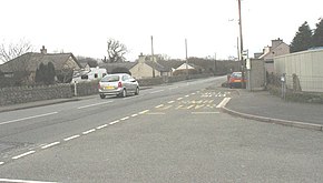
 The A499 at Bethesda Bach The A499 at Bethesda Bach | |
| Route information | |
| Length | 23.4 mi (37.7 km) |
| Major junctions | |
| North end | |
| Major intersections | |
| South end | Abersoch |
| Location | |
| Country | United Kingdom |
| Constituent country | Wales |
| Road network | |
The A499 road is the major road of the Llŷn peninsula in North Wales.
Its northern terminus is a roundabout with the A487 trunk road between Llanwnda and Llandwrog (53°05′41″N 4°16′57″W / 53.0948°N 4.2824°W / 53.0948; -4.2824 (A499 road (northern end))). It then runs south-westerly along the northern coast of the peninsula, through Clynnog Fawr then turns inland crossing the peninsula to meet the southern coast at Pwllheli, it then follows that southern coast to terminate at Abersoch (52°49′22″N 4°30′19″W / 52.8227°N 4.5054°W / 52.8227; -4.5054 (A499 road (southern end))).
The total length is 23.4 miles. At no point is it a trunk road, although the Welsh Assembly has considered upgrading its status.
Improvements
Work started in February 2008 to upgrade the road between Aberdesach and Llanaelhaearn and also bypass Clynnog Fawr. This work is expected to complete in Summer 2009. Previous work in 2006/2007 had cleared the new route of trees and erected boundary fencing.
See also
References
Map all coordinates using OpenStreetMapDownload coordinates as:
- Gwynedd Council response to the Welsh Assembly Government Archived 23 June 2008 at the Wayback Machine
- Welsh Assembly Government: Long-term review of strategic road network
- Gwynedd Council Press Release Nov 2007 Archived 26 November 2007 at the Wayback Machine
| A roads in Zone 4 of the Great Britain road numbering scheme | ||
|---|---|---|
| ||
| ||
52°58′16″N 4°24′03″W / 52.9711°N 4.4009°W / 52.9711; -4.4009 (A499 road)
This Wales road or road transport-related article is a stub. You can help Misplaced Pages by expanding it. |