| Lake Agnococha | |||||||||||||||||
|---|---|---|---|---|---|---|---|---|---|---|---|---|---|---|---|---|---|
 | |||||||||||||||||
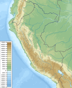
| Location | Peru Huancavelica Region | ||||||||||||||||
| Coordinates | 13°07′16″S 75°09′15″W / 13.12111°S 75.15417°W / -13.12111; -75.15417 | ||||||||||||||||
| Max. length | 3.54 km (2.20 mi) | ||||||||||||||||
| Max. width | 1.80 km (1.12 mi) | ||||||||||||||||
| Surface elevation | 4,714 m (15,466 ft) | ||||||||||||||||
Dam
| |||||||||||||||||
Lake Agnococha (possibly from Quechua aknu beautiful, qucha lake) is a lake in Peru located in the Huancavelica Region, Castrovirreyna Province, Santa Ana District. It is situated at a height of approximately 4,714 m (15,466 ft), about 3.54 km long and 1.80 km at its widest point. Agnococha lies north of a larger lake named Orcococha.
The Agnococha dam was erected in 1957. It is 147 m (161 yd) long and 19 m (62 ft) high. The reservoir has a volume of 74,000 m (60 acre⋅ft) and a capacity of 30,500,000 m (24,700 acre⋅ft).
References
- Teofilo Laime Ajacopa (2007). Diccionario Bilingüe: Iskay simipi yuyayk’anch: Quechua – Castellano / Castellano – Quechua (PDF). La Paz, Bolivia: futatraw.ourproject.org.
- escale.minedu.gob.pe - UGEL map of the Castrovirreyna Province (Huancavelica Region)
- Recursos Hídricos del Perú en Cifras, Boletín Técnico de Recursos Hídricos 2010, Autoridad Nacional del Agua, Ministerio de Agricultura, Peru
This Huancavelica Region geography article is a stub. You can help Misplaced Pages by expanding it. |
