| Alai-Western Tian Shan steppe | |
|---|---|
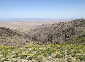
 Nuratau Mountains and Aydar Lake Nuratau Mountains and Aydar Lake | |
 Ecoregion territory (in purple) Ecoregion territory (in purple) | |
| Ecology | |
| Realm | Palearctic |
| Biome | Temperate grasslands, savannas, and shrublands |
| Geography | |
| Country | Kazakhstan, Uzbekistan, Turkmenistan |
| Coordinates | 40°30′N 67°12′E / 40.5°N 67.2°E / 40.5; 67.2 |
The Alai-Western Tian Shan steppe ecoregion (WWF ID: PA0801) covers the foothills on the western edge of the Tien Shan and Alay Mountains of Central Asia. This territory is mostly in southeastern Uzbekistan, with a portion running north into Kazakhstan on the east side of the Syr Darya River, and a small portion in Turkmenistan.
Location and description
The ecoregion stretches 650 km from north to south, from 50 km north of the city of Turkistan in Kazakhstan to Magdanly on the eastern tip of Turkmenistan. The band of foothills is about 250 km west to east, but an additional 250 km reaches into the Fergana Valley of the far east of Uzbekistan. On the west is the Kyzylkum Desert, part of the Central Asian southern desert ecoregion. To the north is the Central Asian northern desert. To the east is the Gissaro-Alai open woodlands ecoregion. Rivers running through the ecoregion support very narrow corridors of the Central Asian riparian woodlands ecoregion. The large (4,000 km2) Aydar Lake sits in a saline depression in the middle of the region.
Climate
The climate of the ecoregion is Humid continental climate - Hot, dry summer sub-type (Köppen climate classification Dsa), with large seasonal temperature differentials and a hot summer (at least one month averaging over 22 °C (72 °F), and mild winters. The driest month between April and September does not have more than 30 millimetres of precipitation. Precipitation averages 300-600 mm/year.
Flora
The lower altitude hills display low herbaceous cover known as savannoids, with Bulbous meadow-grass (Poa bulbosa), sedges (Carex pachystilis), and Artemisia. Biodiversity is high, with over 2,000 species of plants recorded in the region. Higher elevations see ephemeroid grasses such as Elymus (syn. Elytrigia) and Bulbous barley (Hordeum bulbosum).
References
- ^ "Alai-Western Tian Shan steppe". Encyclopedia of the Earth. Retrieved June 22, 2020.
- "Map of Ecoregions 2017". Resolve, using WWF data. Retrieved September 14, 2019.
- Kottek, M.; Grieser, J.; Beck, C.; Rudolf, B.; Rubel, F. (2006). "World Map of Koppen-Geiger Climate Classification Updated" (PDF). Gebrüder Borntraeger 2006. Retrieved September 14, 2019.
- "Dataset - Koppen climate classifications". World Bank. Retrieved September 14, 2019.