District in Qazvin, Iran
| Rudbar-e Alamut-e Sharqi District Persian: بخش رودبار الموت شرقی | |
|---|---|
| District | |
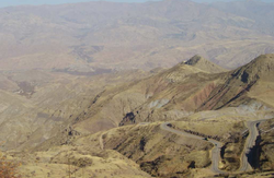
 Landscape in Alamut region Landscape in Alamut region | |
 | |
| Coordinates: 36°26′00″N 50°35′36″E / 36.43333°N 50.59333°E / 36.43333; 50.59333 | |
| Country | Iran |
| Province | Qazvin |
| County | Qazvin |
| Capital | Moallem Kalayeh |
| Population | |
| • Total | 13,701 |
| Time zone | UTC+3:30 (IRST) |
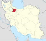
Rudbar-e Alamut-e Sharqi District (Persian: بخش رودبار الموت شرقی) is in Qazvin County, Qazvin province, Iran. Its capital is the city of Moallem Kalayeh.
Demographics
Language and ethnicity
The majority of people in the district are Tats who speak a dialect of the Tati language. A minority of Azerbaijani people also live in the district.
Population
At the time of the 2006 National Census, the district's population was 12,519 in 4,128 households. The following census in 2011 counted 9,801 people in 3,673 households. The 2016 census measured the population of the district as 13,701 inhabitants in 5,133 households.
Administrative divisions
| Administrative Divisions | 2006 | 2011 | 2016 |
|---|---|---|---|
| Alamut-e Bala RD | 4,398 | 3,622 | 5,067 |
| Alamut-e Pain RD | 3,596 | 2,999 | 3,241 |
| Moallem Kalayeh RD | 2,329 | 1,573 | 3,170 |
| Moallem Kalayeh (city) | 2,196 | 1,607 | 2,223 |
| Total | 12,519 | 9,801 | 13,701 |
| RD = Rural District | |||
See also
- Dineh Kuh, "The Village of Mothers"
Notes
- Formerly Rudbar-e Alamut District (بخش رودبار الموت)
References
- OpenStreetMap contributors (16 September 2024). "Rudbar-e Alamut-e Sharqi District (Qazvin County)" (Map). OpenStreetMap (in Persian). Retrieved 16 September 2024.
- ^ Census of the Islamic Republic of Iran, 1395 (2016): Qazvin Province. amar.org.ir (Report) (in Persian). The Statistical Center of Iran. Archived from the original (Excel) on 30 November 2021. Retrieved 19 December 2022.
- Habibi, Hassan (c. 2023) . Approval of the organization and chain of citizenship of elements and units of the national divisions of Zanjan province, centered in Zanjan city. lamtakam.com (Report) (in Persian). Ministry of the Interior, Defense Political Commission of the Government Council. Notification 82844/T141K. Archived from the original on 16 December 2023. Retrieved 16 December 2023 – via Lam ta Kam.
- Maciuszak, Kinga (1995). "Some Remarks on the Northern Iranian Dialect of the Alamūt Region". Iran. 33: 111–114. doi:10.2307/4299928. JSTOR 4299928.
- مقدمه کتاب «دستور زبان گویشهای تاتی جنوبی»، پروفسور احسان یارشاطر، لاهه - پاریس ١٩٦٩
- گونههای زبانی تاتی، دونالد استیلو، ۱۹۸۱
- مقاله «بررسی گویش تاتی الموت»، پرویز البرزی ورکی، ۱۳۷۰، دانشگاه تهران
- "الموت". Archived from the original on 27 January 2016. Retrieved 7 January 2016.
- تاتهای ایران و قفقاز، علی عبدلی، انتشارات مهدی رضایی، تهران، ۱۳۸۹
- مقاله «بررسی گویش مراغی در روستای موشقین»، حسینعلی رسولی، ۱۳۶۹، دانشگاه تهران
- «گونههای زبانی تاتی»، دونالد استیلو، ۱۹۸۱؛ ۷-ب) گونههای مراغهای در منطقه رودبار علیا (رودبار الموت)
- مقاله «زبانهای ایرانی الموت»، دکتر احسان یارشاطر، علوم انسانی، کاوه (مونیخ)، آذر ۱۳۴۸ - شماره ۲۷.
- تاتی و مراغی
- مقاله «گویش مراغی»، ابوالفضل پرهیزکاری، ۱۳۷۸.
- "رودبار شهرستان". Archived from the original on 30 August 2017. Retrieved 7 January 2016.
- خواندنیها
- "الموت من". Archived from the original on 19 January 2021. Retrieved 12 February 2021.
- ^ Census of the Islamic Republic of Iran, 1385 (2006): Qazvin Province. amar.org.ir (Report) (in Persian). The Statistical Center of Iran. Archived from the original (Excel) on 20 September 2011. Retrieved 25 September 2022.
- ^ Census of the Islamic Republic of Iran, 1390 (2011): Qazvin Province. irandataportal.syr.edu (Report) (in Persian). The Statistical Center of Iran. Archived from the original (Excel) on 19 January 2023. Retrieved 19 December 2022 – via Iran Data Portal, Syracuse University.
| Qazvin province, Iran | |||||||||||||
|---|---|---|---|---|---|---|---|---|---|---|---|---|---|
| Capital |  | ||||||||||||
| Counties and cities |
| ||||||||||||
| Sights | |||||||||||||
| populated places | |||||||||||||
This Qazvin County location article is a stub. You can help Misplaced Pages by expanding it. |