Unincorporated rural community in Ontario, Canada
| Alma | |
|---|---|
| Unincorporated rural community | |
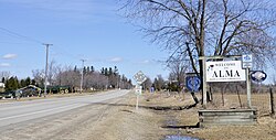
 Entering Alma along County Road 17 Entering Alma along County Road 17 | |
  | |
| Coordinates: 43°43′49″N 80°30′08″W / 43.73028°N 80.50222°W / 43.73028; -80.50222 | |
| Country | Canada |
| Province | Ontario |
| County | Wellington |
| Township | Mapleton |
| Time zone | UTC-5 (Eastern (EST)) |
| • Summer (DST) | UTC-4 (EDT) |
| GNBC Code | FACPP |
Alma is an unincorporated rural community in Mapleton Township, Wellington County, Ontario, Canada.
History
Pioneers began settling along the Elora Saugeen Road, which forms the main street of Alma, during the 1840s.
Alexander MacCrea and his wife settled here in 1848, and built a store. The "MacCrae's Corners" post office was established in 1854, and MacCrae was postmaster.
In 1854, the settlement's name was changed from MacCrae's Corners to "Alma", after the Battle of Alma.
James Ledingham and his family moved to Alma in 1864, and built a saw and chopping mill.
In 1865, St. Andrew's Presbyterian Church was established in Alma. The church moved to a new stone church in Alma in 1892.
The Wellington, Grey and Bruce Railway built a line through Alma in 1870. The line was eventually taken over by Canadian National Railway, and was abandoned in 1983. The Alma railroad station has since been destroyed.
After the railway was constructed, Alma became "a bustling service centre for the local settlers and travellers". Alma was noted for having a post office, wagon maker, weaver, telegraph office, shoemaker, grist mill, several saw mills, several stores, three churches, and four hotels. In 1879, the population was 250.
Wallace Cummings Park in Alma was constructed in 2003 on 25 ha (62 acres) of donated land. The park features a playground, walking trail, toboggan hill, picnic shelter, community hall, wetland boardwalk, and garden labyrinth.
Education
Alma Public School, part of the Upper Grand District School Board, is located in Alma.
Notable people
- James Scarth Gale (1863 – 1937), Presbyterian missionary, educator and Bible translator in Korea.
- George Alexander McQuibban (1886 – 1937), physician and member of the Legislative Assembly of Ontario. McQuibban lived in Alma and had a practice there.
Gallery
-
 Alma, 1910
-
 Houses on Peel Street, 1910
-
 Alma, 2017
-
 Historic locomotive near the former railroad station
References
- ^ "Alma". Natural Resources Canada. October 6, 2016.
- "Mapleton". Statistics Canada. November 2, 2016.
- ^ "About". St. Andrew's Presbyterian Church. Retrieved April 16, 2017.
- ^ "Alma". Rural Routes Ontario. March 29, 2009.
- ^ Campbell, Jean (September 11, 2015). "Alma". Drayton Community News.
- "Biographical Sketches of Early Settlers of Wellington County". Wellington County GenWeb. Retrieved April 16, 2017.
- "The Wellington, Grey & Bruce Railway". Trainweb. December 30, 1997.
- Brown, Ron (2016). Dundurn Railroad 6-Book Bundle. Dundurn. ISBN 9781459736818.
- The County of Wellington Gazetteer and Directory for 1879-80. Armstrong & Delion. 1879. p. 89.
- "Labyrinth & Memory Arboretum Project". Labyrinth Planning Committee. Archived from the original on May 30, 2017. Retrieved April 16, 2017.
- "Alma Public School". Township of Mapleton. Retrieved April 16, 2017.
- Han, Peter (April 1, 2014). "Sent By God". Presbyterian Record.
- "News". Canadian Medical Association Journal. 36 (3): 324–330. March 1937. PMC 1562069.
| Wellington County, Ontario | |
|---|---|
| Cities | |
| Towns | |
| Townships | |
| Unincorporated communities | |
| Separated municipality but remains a census subdivision of the county | |