| Alsike | |
|---|---|
 Alsike Church Alsike Church | |
  | |
| Coordinates: 59°48′N 17°46′E / 59.800°N 17.767°E / 59.800; 17.767 | |
| Country | Sweden |
| Province | Uppland |
| County | Uppsala County |
| Municipality | Knivsta Municipality |
| Area | |
| • Total | 2.38 km (0.92 sq mi) |
| Population | |
| • Total | 5,057 |
| • Density | 2,100/km (5,500/sq mi) |
| Time zone | UTC+1 (CET) |
| • Summer (DST) | UTC+2 (CEST) |
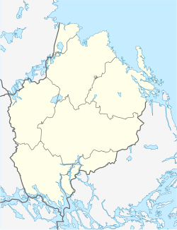
Alsike (Swedish pronunciation: [ˈɑ̂ːlˌsiːkɛ]) is a locality situated in Knivsta Municipality, Uppsala County, Sweden with 2,681 inhabitants in 2010. Alsike is located about 50 km north of Stockholm and only 25 km away from Arlanda Airport. It is also the location of Alsike Abbey. Alsike is located on the Ingegerdsleden, a historic pilgrimage route between Uppsala Cathedral and Storkyrkan in Stockholm. Alsike clover gets its common name from Alsike, Sweden.
References
- ^ "Tätorternas landareal, folkmängd och invånare per km 2005 och 2010" (in Swedish). Statistics Sweden. 14 December 2011. Archived from the original on 27 January 2012. Retrieved 10 January 2012.
- "Statistiska tätorter 2020, befolkning, landareal, befolkningstäthet". Statistics Sweden. 31 December 2020. Retrieved 2 June 2024.
- Jöran Sahlgren; Gösta Bergman (1979). Svenska ortnamn med uttalsuppgifter (in Swedish). p. 4.
- Publications & Information: Alsike Clover Archived 2012-12-30 at the Wayback Machine. Montana State University.
See also
| Localities in Knivsta Municipality, Uppsala County, Sweden | |
|---|---|
| Localities | |
This article about a location in Uppsala County, Sweden is a stub. You can help Misplaced Pages by expanding it. |