17°00′02″N 73°46′38″E / 17.0006888°N 73.7772247°E / 17.0006888; 73.7772247
| This article needs additional citations for verification. Please help improve this article by adding citations to reliable sources. Unsourced material may be challenged and removed. Find sources: "Amba Ghat" – news · newspapers · books · scholar · JSTOR (February 2013) (Learn how and when to remove this message) |
| This article is written like a travel guide. Please help improve the article by introducing an encyclopedic style or move the content to Wikivoyage. (November 2023) |
| Amba Ghat | |
|---|---|
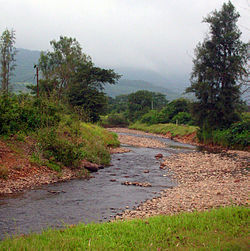
 A stream near Amba hamlet close to the pass. A stream near Amba hamlet close to the pass. | |
| Location | Maharashtra, India |
| Range | Sahyadri |
| Coordinates | 17°00′02″N 73°46′38″E / 17.0006888°N 73.7772247°E / 17.0006888; 73.7772247 |
 | |
Amba Ghat is a mountain pass on Ratnagiri-Kolhapur road (NH 204) in Maharashtra, India, at a height of 2000 ft above sea-level, This ghat lies in the Sahyadri mountain ranges (Western Ghats) and has picturesque mountain-scapes and a pleasant climate. It is situated near Shahuwadi, Kolhapur district, and has nearby interesting places are Pawankhind and Vishalgad fort. It is a convenient weekend destination for Kolhapur tourists.
The area has also become a venue for paragliding sport.
References
- Amba Ghat
- "Pray for more dhoop, this Diwali". The Times of India. 19 October 2009. Archived from the original on 11 January 2014.
- "20 armymen to paraglide from Kamshet to Ratnagiri". The Times of India. 10 November 2009. Archived from the original on 4 January 2013.
| Kolhapur district topics | |||||
|---|---|---|---|---|---|
| History |  | ||||
| Geography | |||||
| Cities and towns | |||||
| Transport | |||||
| Visitor attractions | |||||
| Culture | |||||
| Education | |||||
| Lok Sabha constituencies | |||||
| Vidhan Sabha constituencies |
| ||||
| Taluka/Tehsil | |||||
| Stadiums | |||||
‡ This constituency also has portions in Sangli district
| |||||
This Maharashtra-related article is a stub. You can help Misplaced Pages by expanding it. |