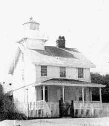
 The 1872 Amelia Island North Range Lighthouse The 1872 Amelia Island North Range Lighthouse | |
| Location | mouth of the St. Mary's River Florida United States |
|---|---|
| Coordinates | 30°42′12″N 81°26′18″W / 30.7034°N 81.4383°W / 30.7034; -81.4383 |
| Tower | |
| Constructed | 1858 |
| Construction | wood |
| Shape | square tower atop keeper's house |
| Markings | white tower and lantern |
| Light | |
| First lit | 1872 (rebuilt) |
| Deactivated | 1899 |
| Lens | Sixth order Fresnel lens |
| Characteristic | F R |
The Amelia Island North Range Light was built to mark a channel over the sandbar at the mouth of the St. Mary's River, which led to the harbor at Fernandina Beach, Florida, on Amelia Island. It consisted of a lighthouse and a front range tower with a light, arranged so that when ships could see one light above the other, they were lined up with the channel. During the Civil War Confederate forces removed the lenses from the lights. Union forces seized Fernandina Beach, Fort Clinch and the lighthouse in 1862.
It is known that the front range tower was destroyed during the war. There is no record of when the lighthouse was destroyed, but a new lighthouse was built in 1872. As the channel over the sand bar shifted with time, the front range light was periodically moved to maintain an alignment with the channel. In 1887 the rear range light was moved from the lighthouse to a tramway to permit proper adjustments to be made to the alignment. The light was decommissioned in 1899 after the channel was sufficiently marked with buoys. The lighthouse was listed in a survey in 1924, but has since disappeared.
See also
References
- Rowlett, Russ. "Lighthouses of the United States: Eastern Florida and the Keys". The Lighthouse Directory. University of North Carolina at Chapel Hill. Retrieved 2016-06-28.
- Amelia Island Rear Range Light Lightouse Explorer. Retrieved 28 June 2016
- "Historic Light Station Information and Photography: Florida". United States Coast Guard Historian's Office. Archived from the original on 2017-05-01. Retrieved June 29, 2008.
External links
- Florida Lighthouse Page - Amelia Island North Range Lighthouse History - accessed January 16, 2006, recovered using Wayback Machine on January 22, 2007
30°42′12″N 81°26′18″W / 30.7034°N 81.4383°W / 30.7034; -81.4383
Categories: