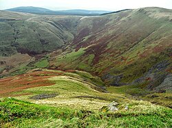
| Annanhead Hill | |
|---|---|
 Annanhead Hill above Devil's Beef Tub Annanhead Hill above Devil's Beef Tub | |
| Highest point | |
| Elevation | 478 m (1,568 ft) |
| Coordinates | 55°24′15″N 3°29′19″W / 55.40417°N 3.48861°W / 55.40417; -3.48861 |
| Geography | |
 | |
| Parent range | Moffat Hills |
| OS grid | NT 05834 13251 |

Annanhead Hill is a 478-metre (1,568 ft) summit in the Moffat Hills of Scotland. It lies on the boundary between the Scottish Borders and Dumfries and Galloway, 9 kilometres (5.6 mi) north of Moffat, in the Southern Uplands.
Annanhead is one of four hills encircling the Devil's Beef Tub, the headwaters of River Annan.
The hill is crossed by the Annandale Way hiking trail designated in 2009.
References
- ^ "Annanhead Hill". Gazetteer for Scotland. Retrieved 11 June 2023.
- ^ "Annanhead Hill". Trigpointing UK. Retrieved 11 June 2023.
- Louisa Finch (1 April 2013), "The big picture: The Devil's Beef Tub", Scotland Outdoors, archived from the original on 7 April 2013, retrieved 14 May 2013
- "Route description: Moffat - Devils Beef Tub - Moffat", Annandale Way official website, Government of Scotland et al., retrieved 14 May 2013,
The Devil's Beef Tub section of this walk ... climb onto Annanhead Hill and a range that rims the upper limits of the Annan catchment. ...
External links
 Media related to Annanhead Hill at Wikimedia Commons
- The Moffat Hills at Summitpost.com
- "Topographic map of Annanhead Hill". opentopomap.org. Retrieved 11 June 2023.