You can help expand this article with text translated from the corresponding article in Croatian. (September 2014) Click for important translation instructions.
|
Antonio Zatta (fl. 1757 – April 2, 1797) was an Italian cartographer and publisher who was based in Venice. He may have lived from about 1722 to 1804. One of his major contributions includes the Atlante Novissimo, a four volume atlas of the world. Also, his grand study of St Mark's Basilica in Venice, printed in 1761.

He also published an edition of the plays of Goldoni with engravings in 1789.
Gallery
-
 1784 map of Chinese Tartary and Korea
-
1782 map of the Kingdom of Naples
-
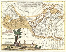
 1776 map of the North Pacific coast, particularly of North America. Note the erroneous presence of a Chinese colony "Fou-Sang", and the rumoured Strait of Anián.
-
 1779 map of the Kingdom of Bohemia
-
 1781 map of Eastern Europe
-
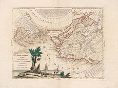
 Another version of the above map of the North Pacific (1776)
See also
References
- "Zatta, Antonio (1722-1804) international form". catalogue.bnf.fr. Retrieved September 25, 2014.
- "Antonio Zatta (1757-1797)". christina.com. Archived from the original on February 18, 2013. Retrieved September 25, 2014.
External links
- Antonio Zatta at Geographicus.com
- Antonio Zatta at alteagallery.com
- Antonio Zatta at bergbook.com
- Works by or about Antonio Zatta at the Internet Archive