Unincorporated community in New Mexico, United States
| Arabela, New Mexico | |
|---|---|
| Unincorporated community | |
  | |
| Coordinates: 33°35′13″N 105°10′24″W / 33.58694°N 105.17333°W / 33.58694; -105.17333 | |
| Country | United States |
| State | New Mexico |
| County | Lincoln |
| Elevation | 5,479 ft (1,670 m) |
| Time zone | UTC-7 (Mountain (MST)) |
| • Summer (DST) | UTC-6 (MDT) |
| ZIP codes | 88351 |
| Area code | 575 |
| GNIS feature ID | 903252 |
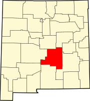
Arabela is an unincorporated community located in Lincoln County, New Mexico, United States. Arabela is located in a rural part of eastern Lincoln County, 23.2 miles (37.3 km) east of Capitan.
A post office was established in 1901 and named Arabela by Andy Richardson, who became smitten with a local Apache woman, Arabela Barela. Barela, who with her sisters Damiana Barela and Carolina “Caro” Romero, owned and operated several cathouses in the area. The post office closed in 1928.
References
- "Postmaster Finder - Post Offices by ZIP Code". United States Postal Service. Archived from the original on October 17, 2020. Retrieved November 30, 2014.
- "Arabela". Geographic Names Information System. United States Geological Survey, United States Department of the Interior.
- Julyan, Robert (1996). The Place Names of New Mexico. University of New Mexico Press. p. 20. ISBN 978-0-8263-1689-9.
| Municipalities and communities of Lincoln County, New Mexico, United States | ||
|---|---|---|
| County seat: Carrizozo | ||
| City |  | |
| Town | ||
| Villages | ||
| CDP | ||
| Other unincorporated communities | ||
| Ghost towns | ||
This New Mexico state location article is a stub. You can help Misplaced Pages by expanding it. |