| Arroyo Simi | |
|---|---|
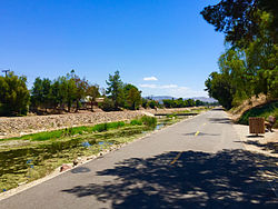
 Arroyo Simi seen from Frontier Park. Arroyo Simi seen from Frontier Park. | |
| Location | |
| Country | United States |
| Physical characteristics | |
| Source | |
| • location | Corriganville Park, Simi Valley |
| Mouth | |
| • location | Merges with Arroyo Las Posas in Moorpark, discharges to the Pacific by Mugu Lagoon |
| Length | 19 mi (31 km) |
| Basin features | |
| River system | Calleguas Creek |
| Tributaries | |
| • left | Runkle Canyon- and Bus Canyon Creeks, and Erringer Drain |
| • right | Aaamos Canyon-, Dry Canyon-, Tapo Canyon-, Las Llajas Canyon-, and White Oak Creeks, and North Simi Drain |
The Arroyo Simi (Spanish for "Small Stream of Simi", sometimes also referred to as Simi Creek) is a 19-mile (31 km) westwards-running creek, located in California, United States, running from the city of Simi Valley and crosses the valley from east to west, before entering the city of Moorpark. It originates at Corriganville Park by the Santa Susana Pass, travels for 12 miles (19 km) through Simi Valley, leaves the city limits of Oak Park at the western end of Simi Valley, continues for seven miles in Moorpark where it merges with Arroyo Las Posas by Hitch Road. It is a tributary to the Calleguas Creek, which enters the Pacific Ocean by its estuary at Mugu Lagoon by Naval Air Station Point Mugu. Arroyo Simi drains an area of 343 square miles in southern Ventura County. In its natural state, it is an ephemeral creek, which is only seasonally filled during winter time and periods of heavy rain. Today it is for the most part a concrete lined water drain that flows year round. Tributaries to the Arroyo Simi include the Alamos, Sycamore, Dry, Tapo, Las Llajas, White Oak, Runkle, and Bus Canyon Creeks, as well as the Erringer Road and North Simi Drains.
Arroyo Simi Greenway is an ongoing construction project by the City of Simi Valley to increase the recreational use of its river parkways. The project includes new paved hiking and biking trails along the Arroyo Simi, exhibit signs, sixteen new trail entries, and more. The area is administered as the Arroyo Simi Bike Path by the Rancho Simi Recreation and Park District (RSRPD). It is home to native flora, fish, and birds. It is home to fish species such as the brown bullhead, green sunfish, bluntnose minnow, and mosquitofish. It is an important habitat for various species of freshwater-nesting birds in the Simi Valley. Some of the species include the great blue heron, white-faced ibis, black-crowned night heron, green heron, black-necked stilt, great egret, snowy egret, belted kingfisher, black phoebe, killdeer, common yellowthroat, greater yellowlegs, American coot, and mallard.
References
- ^ "Our Arroyo Ecosystem". Archived from the original on 2015-06-23. Retrieved 2015-06-08.
- "ARROYO LAS POSAS AND ARROYO SIMI ARUNDO REMOVAL FEASIBILITY AND WATER SAVINGS STUDY" (PDF). January 2015. Archived from the original (PDF) on 2015-07-25. Retrieved 2015-06-08.
- ^ "(Page 1)" (PDF). Archived from the original (PDF) on 2015-07-25. Retrieved 2015-06-08.
- ^ Appleton, Bill (2009). Santa Susana. Arcadia Publishing. Page 27. ISBN 9781439638200.
- Schad, Jerry (2009). Afoot and Afield: Los Angeles County: A Comprehensive Hiking Guide. Wilderness Press. Page 253. ISBN 9780899974996.
- "RSRPD Arroyo Simi Greenway Update". Rsrpd.org. Archived from the original on 2015-06-23. Retrieved 2015-06-08.
- "An Overview of Phase 1 and Phase 2 of the Arroyo Simi Greenway Project" (PDF). Archived from the original (PDF) on January 23, 2016. Retrieved 2024-04-18.
- Technical description nwrc.usgs.gov Archived 2016-03-04 at the Wayback Machine
- "Archived copy" (PDF). Archived from the original (PDF) on 2015-06-23. Retrieved 2015-06-08.
{{cite web}}: CS1 maint: archived copy as title (link) - Simon, Melissa (2015-04-10). "Arroyo greenway makes progress | www.simivalleyacorn.com". Simi Valley Acorn. Archived from the original on 2015-07-26. Retrieved 2015-06-08.
- Rachel McGrath (2014-07-02). "Arroyo Simi Greenway taking shape". VC-Star. Retrieved 2015-06-08.
- "RSRPD Arroyo Simi Bike Path". Rsrpd.org. Archived from the original on 2015-06-11. Retrieved 2015-06-08.
- "Archived copy" (PDF). Archived from the original (PDF) on 2015-07-25. Retrieved 2015-06-08.
{{cite web}}: CS1 maint: archived copy as title (link) - (Page 30). Archived January 23, 2016, at the Wayback Machine
- (Pages 30–33). Archived January 23, 2016, at the Wayback Machine
34°16′18″N 118°55′29″W / 34.271619°N 118.9246°W / 34.271619; -118.9246
Categories: