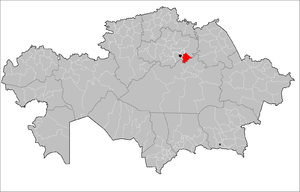
| Arshaly | |
|---|---|
| District | |
| Arşaly audany | |
 | |
 | |
| Country | |
| Region | Aqmola Region |
| Administrative center | Arshaly |
| Founded | 1930 |
| Government | |
| • Akim | Aidar Itemgenovich Baymanov |
| Area | |
| • Total | 2,200 sq mi (5,800 km) |
| Population | |
| • Total | 27,119 |
| Time zone | UTC+6 (East) |
Arshaly District (Kazakh: Аршалы ауданы, Arşaly audany) is a district of Akmola Region in northern Kazakhstan. The administrative center of the district is the settlement of Arshaly. Population: 27,940 (2009 Census results); 29,620 (1999 Census results).
Geography
The district is located in the south-east of Akmola region, on the Kazakh melkosopochnik. The area of the territory is 5.8 thousand km, which is 3.75% of the entire territory of the region (the 14th district in terms of territory size in the region). The length from west to east is 100 km, from south to north — 110 km.
Borders:
- with the districts of Akmola region:
- in the north-west with the Tselinograd district;
- in the northeast with the Yerementau district;
- with districts of Karaganda region:
- in the south with Osakarovsky district;
- in the southwest with the Nurinsky district.
The eastern part is occupied by the low southern spurs of the Yerementau Mountains. The climate is continental. Winter is cold, long-lasting; average temperature in January -17°C; summer is moderately hot, average temperature in July is 20°C. The average annual precipitation is 300-350 mm . The Ishim River flows through the territory of the district with tributaries of the Kyzylmol and Olenty. Most small rivers dry up in summer. Many lakes. The largest: Ulken and Kishi Saryoba, Balyktykol, Tanakol, Baidaly, Shalkar, Kyzylkol and others.
History
The district was formed initially as Vishnevsky, by the Decree of the Presidium of the Karaganda Regional Executive Committee of February 10, 1935 as a result of the unbundling of the Akmola and Telman districts of the Karaganda region. The administrative center of the district was the village of Vishnevka (now the village of Arshaly).
By the decree of the Presidium of the Supreme Soviet of the Kazakh SSR of October 14, 1939, Vishnevsky district was transferred to the newly formed Akmola region.
By the Decree of the President of the Republic of Kazakhstan dated November 14, 1997 No. 3759 "On renaming certain administrative-territorial units of the Akmola region and changing their transcription" Vishnevsky district was renamed Arshalynsky district.
Administrative division
Arshalynsky district — as a separate administrative unit of the 2nd level of Kazakhstan, includes 13 administrative-territorial entities of the 3rd level, including: 1 village administration and 12 rural districts.
| № | Administrative division | Administrative center |
|---|---|---|
| 1 | Arshaly | Settlement of Arshaly |
| 2 | Akbulak Rural Okrug | Akbulak village |
| 3 | Arnasay Rural District | Arnasay village |
| 4 | Anar Rural District | Anar station |
| 5 | Bersuat Rural District | Bersuat village |
| 6 | Bulaksay Rural District | Bulaksai village |
| 7 | Volgodonovsky Rural District | Volgodonovka village |
| 8 | Zhibek Zholy Rural District | Zhibek Zholy village |
| 9 | Izhevsk Rural District | Izhevsk village |
| 10 | Konstantinovsky Rural District | Konstantinovka village |
| 11 | Mikhailovsky Rural District | Mikhailovka village |
| 12 | Saryobinsky Rural district | Saryoba village |
| 13 | Turgen Rural District | Turgen village |
References
- "Айдар Байманов назначен акимом Аршалынского района". kokshetv.kz. 2021-02-17.
- "Департамент статистики Акмолинской области". Archived from the original on 2011-05-28. Retrieved 2010-05-13.
- ^ "Население Республики Казахстан" [Population of the Republic of Kazakhstan] (in Russian). Департамент социальной и демографической статистики. Retrieved 8 December 2013.
- "Аршалы: территория инноваций". apgazeta.kz (in Russian). 2016-09-28. Retrieved 2022-11-30.
- "Большая перемена". vlast.kz (in Russian). 2015-08-24. Retrieved 2022-11-30.
- "Аршалынский район". map.akmol.kz (in Russian). Retrieved 2022-11-30.
- "История поселка Аршалы (Борисовка, Вишневка, Аршалы)". arshalytoday.wixsite.com (in Russian). Retrieved 2022-11-30.
- "Статья «История Акмолы – Астаны в архивных документах»". obl-archive.akmo.gov.kz (in Russian). 2017-07-21. Retrieved 2022-11-30.
- "О переименовании отдельных административно-территориальных единиц Акмолинской области и изменении их транскрипции". adilet.zan.kz (in Russian). 1997-11-14. Retrieved 2022-11-30.
- "Об утверждении Межрегиональной схемы территориального развития Астанинской агломерации". zakon.uchet.kz (in Russian). 2022-01-16.
| Akmola Region | ||
|---|---|---|
| Capital: Kokshetau | ||
| Cities |  | |
| Districts | ||
| Other settlements | ||
52°43′40″N 61°08′07″E / 52.72778°N 61.13528°E / 52.72778; 61.13528
This Kazakhstan location article is a stub. You can help Misplaced Pages by expanding it. |