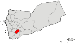
| Ash Shu'ayb District مديرية الشعيبAlshaib | |
|---|---|
| District | |
 | |
 | |
| Country | |
| Governorate | Dhale |
| Area | |
| • Total | 338 km (131 sq mi) |
| Elevation | 2,084 m (6,837 ft) |
| Population | |
| • Total | 38,261 |
| Time zone | UTC+3 (Yemen Standard Time) |
Ash Shu'ayb District is a district of the Dhale Governorate, Yemen. As of 2003, the district had a population of 38,261 inhabitants.
Location
Ash Shu'ayb district (Shuaib) is located between longitude (44.833) eastward, and latitude (13.83) northward. Al Shu'ayb is located on a plateau ranging from 3000 to 3,500 feet in the north-west of Aden. It is about 140 miles away, and the Shuaib (North) and North (West) The eastern side, the Dhale Governorate and the from the southern side. Among the most important villages: Al-Awabel (the capital of the Directorate), Al Madu, Hathara, Houf, Lasbour, Qazaah, Bakhael, Maklan, Rabat, Kahreeh, Jabbab, Ja'afer, Lnajud, lwdeeha, Gabel Kadapa, Raghb.
Al Shuaib Directorate enjoys a cool climate for its rise above sea level.
Notable mountains in the district include Hay'd Urshi, Jabal Harir and Jabal Khudr.
References
- ID Geonames ash shu,ayb 6940881
- "Districts of Yemen". Statoids. Archived from the original on 29 November 2010. Retrieved October 17, 2010.
- ^ "Yemen: Al Dhale'e Governate" (PDF). Humanitarian Response. United Nations Office for the Coordination of Humanitarian Affairs. March 30, 2014. Archived (PDF) from the original on 2021-04-22. Retrieved April 23, 2021.
| Capital: Dhale | |
| Districts | |
13°50′N 44°50′E / 13.833°N 44.833°E / 13.833; 44.833
This article about a location in Yemen is a stub. You can help Misplaced Pages by expanding it. |