| This article needs additional citations for verification. Please help improve this article by adding citations to reliable sources. Unsourced material may be challenged and removed. Find sources: "Sette Comuni" – news · newspapers · books · scholar · JSTOR (January 2021) (Learn how and when to remove this message) |


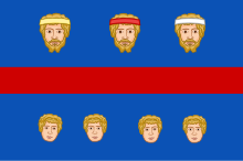
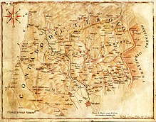
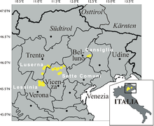
The Sette Comuni (Cimbrian: Siben Komoin, German: Sieben Gemeinden) are seven comuni that formed a Cimbrian enclave in the Veneto region of north-east Italy. The area is also known as the Altopiano dei Sette Comuni or Asiago Plateau, and it was the site of a major battle between Austrian and Italian forces on the Alpine Front of World War I. The most important comune is that of Asiago, for which Asiago cheese is named. Cimbrian, a variety of Upper German, was the native language, and the area was ethnically and culturally distinct from the surrounding comuni. The Sette Comuni are located in mountainous territory, ranging from 500 to 2300 metres above sea level.
Comuni
| Comune | Cimbrian | German | Inhabitants | Altitude (m) | Notes |
| Asiago | Sléghe/Schlège | Schlägen | 6533 | 1001 | |
| Enego | Ghenébe/Jenève | Jeneve | 1927 | 800 | |
| Foza | Vüsche/Vütsche | Fütze | 731 | 1083 | |
| Gallio | Gell(e)/Ghèl | Gelle | 2331 | 1093 | |
| Lusiana | Lusaan | Lusian | 2833 | 752 | |
| Roana | Robàan | Rovan or Rain | 4245 | 994 | |
| Rotzo | Rotz | Ross | 620 | 938 | |
| Conco | Kunken | 2252 | 830 | the "eighth comune", a frazione of Lusiana until 1796 |
History

The seven comuni formed into a loose commonwealth in 1310. They were historically under the suzerainty of the Milanese House of Visconti and then under the Republic of Venice. Under both they enjoyed wide cultural and political autonomy in exchange for their loyalty. This autonomous status came to an end with the Napoleonic Wars and the demise of the Serenìsima in 1807.
World War I
See also: Battle of AsiagoDuring the First World War the territory was located along the border between the Kingdom of Italy and the Austro-Hungarian Empire. Many battles took place here between 1915 and 1918 (the most important one was the battle of Asiago). Almost all the towns were completely destroyed by the war.
-
 Asiago destroyed during World War I
-
 Austro-Hungarian soldiers in the woods of the Sette Comuni (Mount Zebio)
Cimbrian

Cimbrian has gone extinct in most of the comuni. Only in Robàan and its district of Mittebald/Toballe (Mittewald, Mezzaselva) has Cimbrian survived.
Robàan is home to the Agustin Prunner Cultural Institute, which is a repository of the Cimbrian culture and cooperates with other linguistic enclaves in Lusern, Fersental, Sappada, Sauris, the Thirteen Communities and Timau. Vestiges of the language are found in family and place names, which are mostly still Cimbrian.
See also
References
- l'Altopiano di Asiago e la Spettabile Reggenza dei Sette Comuni (in Italian). magicoveneto.it. Accessed September 2013.
External links
This Italian location article is a stub. You can help Misplaced Pages by expanding it. |

