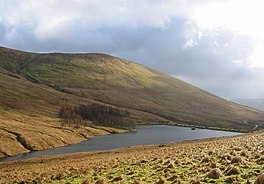
National grid reference NS27609150
| Auchengaich Reservoir | |
|---|---|
 | |
 | |
| Location | Glen Fruin, Scotland |
| Coordinates | 56°05′10″N 4°46′14″W / 56.0860°N 4.7705°W / 56.0860; -4.7705 |
| Type | Reservoir |
| Primary outflows | Auchengaich Burn |
| Basin countries | Scotland, United Kingdom |
| Surface area | 34,000 m (370,000 sq ft) |
| Surface elevation | 244 m (801 ft) |
Auchengaich Reservoir was created in 1942 through the construction of an earthfill dam built by the military to supply water to Helensburgh and the Gareloch during World War II.
See also
Sources
This Scotland-related article is a stub. You can help Misplaced Pages by expanding it. |