| This article needs additional citations for verification. Please help improve this article by adding citations to reliable sources. Unsourced material may be challenged and removed. Find sources: "Avenue Charles-de-Gaulle" Neuilly-sur-Seine – news · newspapers · books · scholar · JSTOR (December 2015) (Learn how and when to remove this message) |


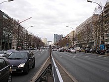
The Avenue Charles-de-Gaulle (French pronunciation: [avny ʃaʁl də ɡol]) is an avenue in Neuilly-sur-Seine, Paris, France, named after Charles de Gaulle.
The avenue forms part of the Route nationale 13. Until 1971, it was called the Avenue de Neuilly, a rare case in France where the road bears the name of the commune in which it is found. The Avenue Charles-de-Gaulle continues along Paris's Axe historique, which stretches from the original Palais des Tuileries to the Porte Maillot, and which finishes at the Pont de Neuilly. It forms a segment of the axe majeur, which links Paris and La Défense. It is used by a daily flow of 160,000 vehicles.
Since 1992, part of the avenue passed underground for 440 metres (1,440 ft), at the exit of Neuilly-sur-Seine. This was due to the completion of the couverture Madrid.
References
- "Avenue Charles de Gaulle, 92200 Neuilly-sur-Seine". MeilleursAgents. Retrieved 23 December 2015.
External links
 Media related to Avenue Charles-de-Gaulle (Neuilly-sur-Seine) at Wikimedia Commons
48°52′59″N 2°15′56″E / 48.8831°N 2.2656°E / 48.8831; 2.2656
This Paris geographical article is a stub. You can help Misplaced Pages by expanding it. |