| Avera | |
|---|---|
| Associated commune of Taputapuatea | |
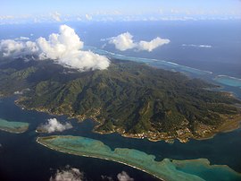
 Raiatea, the island on which Avera is located Raiatea, the island on which Avera is located | |
 | |
| Location of Avera | |
| Coordinates: 16°47′52″S 151°24′4″W / 16.79778°S 151.40111°W / -16.79778; -151.40111 | |
| Country | France |
| Overseas collectivity | French Polynesia |
| Subdivision | Leeward Islands |
| Commune | Taputapuatea |
| Population | 3,440 |
| Time zone | UTC−10:00 |
| Elevation | 15 m (49 ft) |
Avera is an associated commune on the island of Raiatea, in French Polynesia. It is the larger of two villages in French Polynesia with this name, the other being located on the island of Rurutu. It is part of the commune Taputapuatea. According to the 2022 census, it had a population of 3,440.
References
- ^ "Les résultats du recensement de la population 2022 de Polynésie française" [Results of the 2022 population census of French Polynesia] (PDF) (in French). Institut de la statistique de la Polynésie française. January 2023.
This French Polynesia-related geography article is a stub. You can help Misplaced Pages by expanding it. |